Friday, April 30, 2010

Day 60 - 4/30

Daily mileage: 17.1
Total trail mileage: 768.2
Starting location: Bryant Ridge Shelter
Ending location: Marble Spring
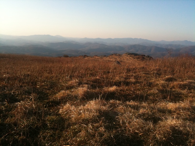
Weather: clear and sunny all day, 42-82 degrees during the day

I am at
http://maps.google.com/maps?q=37.570611,+-79.437275

Wow, I got started late today. I woke up and thought it was 7:00. It
was actually 8:40. And then I read for a bit before starting to
hike. So, I didn't get started until 10, which is the latest I have
started in a while.

My back was hurting a little at the end of yesterday. I had thought
that it was just because I was doing a long day with a relatively
heavy pack (recently resupplied). I think though that it had more to
do with the weight distribution than the weight itself. My food bag
was sitting high yesterday which put alot of weight up above my
shoulders. Today I was able to get the food bag lower in the pack
which felt much better.

There were a few sections today with hundreds of crickets. Whenever I
would move, the ones around me would start hopping all over the place,
like popcorn popping. If I stopped, they would stop. I wish the
other bugs would follow their lead and try to get out of my way
instead of flying straight into my face. I don't understand, they can
avoid my hand trying to swat them, but they can't avoid me walking
down the trail.

I think I will start a bug-o-meter rating system. Level 1 is no
bugs. Level 2 is "hey look at that cute bee flying around". Level 3
is "man, they are annoying". Level 4 is "unbearably annoying". Level
5 is "I need to take a day off not because I am tired or I need a
shower but just to avoid the bugs" AND/OR "I need a blood transfusion
because the bugs stole all my blood". Up until recently, I have been
at Level 1 or 2. The past couple days, I have moved into Level 3.

I heard the Northeast got a foot of snow yesterday. If true, can
someone from up there send me a little? Just a little this time, it
would help kill off some of the bugs and lower the temperature a few
degrees.

I am camping at a campsite tonight. I was expecting it to be a
typical one or two tent site next to a spring, which have been pretty
common. I was completely surprised when there were 29 people here
with tents and tarps all over the place. I started getting all the
normal questions about thruhiking.

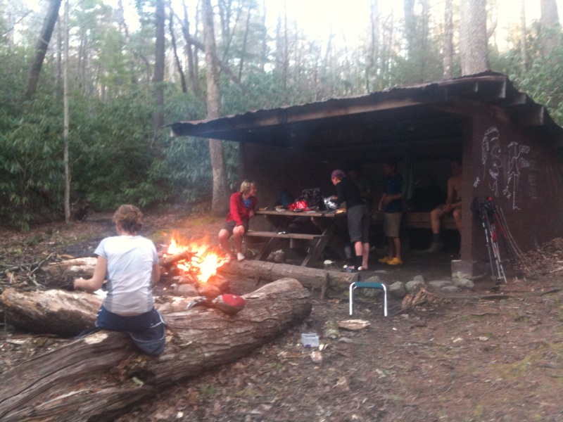
To address Greg's comment. Yes, I'll post a picture of a shelter. I
didn't take any with my phone today and I am not at a shelter tonight,
but I will try to post one tomorrow. They are probably not what you
are picturing. Most are three walls, a roof, and a wooden sleeping
platform. They are spaced about every 5-10 miles or so on average,
and are usually placed near a water source (stream or spring
typically). Most have privies at the site (saves you from having to
dig a cathole when you need to go to the bathroom). Some have been
built recently and some are rather old (I am not sure what the oldest
one on the AT is, but there was one on the Long Trail that was built
in the 30s). They are frequently infested with mice. They are good
meeting places and good places to take a break. A number of people
sleep in them most nights and avoid having to setup a tent.
Unfortunately, they have made a few people lazy and irresponsible and
motivated those people to send home their primary shelter (tent,
hammock, tarp, etc.). Personally I tend to hammock even when I am
near a shelter as the hammock is more comfortable.

Thursday, April 29, 2010

Day 59 - 4/29

Daily mileage: 20.8
Total trail mileage: 751.1
Starting location: Wilson Creek Shelter
Ending location: Bryant Ridge Shelter
Weather: clear and sunny all day, 46 degrees in the morning, 55-77
degrees during the day

I am at
http://maps.google.com/maps?q=37.530134,+-79.585548

Today marked the first day of the Blue Ridge Parkway section. The
trail runs parallel to the road for a while and crosses it many many
times. Today alone it crossed the parkway six times. At least now
isn't peak tourist season so the scenic overlooks aren't mobbed and I
don't hear a million cars whizzing by.

It is nice to see everything green. But, the leaves block some of the
views and now that spring is really here, the bugs are starting to get
annoying. I know it will get worse though. I need to tape a fly
swatter to my trekking pole to more effectively deal with them.

The weather this morning was like yesterday - almost perfect hiking
weather. Cool but not cold and sunny. But then it got rather warm in
the afternoon. It cooled off a little in the late afternoon though.
Another positive about the leaves is that they are providing shade
with the warmer weather.

The shelter tonight is really nice. It is huge! There is a patio and
an upstairs. There are even windows, which is highly unusual. Other
than not having a shower, it is nicer than the Fontana Hilton and the
Partnership shelter. I am here with Shlep, 3 of the guys from last
night (Naptime and I can't remember the other guys' names), and a
section hiker (?). I am even sleeping in the shelter which I haven't
done for a while.

Wednesday, April 28, 2010

Day 58 - 4/28

Daily mileage: 11.2
Total trail mileage: 730.3
Starting location: Daleville, VA
Ending location: Wilson Creek Shelter
Weather: clear and sunny all day, 55-62 degrees during the day, breezy

I am at
http://maps.google.com/maps?q=37.419422,+-79.785531

I broke free from town after breakfast today. Shlep caught back up,
but Dethmarch and Sugarbush were zeroing in town. So, I headed out and
was surprised that my heavy pack (just resupplied) wasn't too bad. My
legs felt good and my feet felt good. Spending the day off was
helpful, but I also got new insoles for my boots. The shoes feel like
new; I just have to ignore the holes in the sides.

I made it to Wilson Creek Shelter by late afternoon. There are a
bunch of people here tonight, mostly new faces. A number of people are
a day or so ahead. I might be able to catch them.

I saw a lot of female mosquitos today. That is not a good sign for the
coming days. I don't think it will be long before the unbearably
annoying swarms of mosquitos are out.

Tuesday, April 27, 2010

Day 57 - 4/27

Daily mileage: 0.0
Total trail mileage: 719.1
Starting location: Daleville, VA
Ending location: Daleville, VA
Weather: partly cloudy all day

I am at
http://maps.google.com/maps?q=37.392376,+-79.907816

Yea, I didn't go anywhere today. I got up, had breakfast, and decided
to take a day off. I did basically nothing all day: just watched tv,
surfed the Internet, and read a lot. This was my first day since
starting the trail when I didn't have to walk or do many town chores.
I did run into Dethmarch and Sugarbush though and had a beer with them
across the street. Back to the trail in the morning...

Monday, April 26, 2010

Day 56 - 4/26

Daily mileage: 15.4
Total trail mileage: 719.1
Starting location: Campbell Shelter
Ending location: Daleville, VA
Weather: cloudy in the morning, partly cloudy in the afternoon, 55-70
degrees during the day, windy in the afternoon

I am at
http://maps.google.com/maps?q=37.392376,+-79.907816

I got up early and made good time until Tinker Cliffs. Then Cookie
Monster, Sockburn, and I made a wrong turn. We walked along the base
of the cliffs for a while before the path we were on ended.
Apparently the AT turned to go on top of the cliffs and we missed the
turn. So, I retraced my steps until I was able to get back on the
trail.

I am actually glad I made the mistake. I was planning on killing some
time at the cliffs as I thought there was a half mile trail around the
cliffs. It turns out there isn't another trail. The AT along the
cliffs had fantastic views, even better than the view from McAfee
Knob. Along the base of the cliffs entailed crawling among the rocks,
which was also pretty cool.

Once I got into town and checked into the motel, I went to the Wendy's
and did the Value-menu Challenge. The Value-menu Challenge involves
eating one of everything on the value menu at a fast food restaurant.
Wendy's is supposedly the hardest. I consumed a Jr. Bacon
Cheeseburger, Crispy Chicken Sandwich, Double Stack Burger, 5pc
Chicken Nuggets, Baked Potato, Small Chili, Side Salad, Caesar Salad,
Spicy Chicken Wrap, Chicken Fillet Wrap, Grilled Chicken Wrap, Value
Sweet Tea, and Value Fries. It was tough to finish the last couple
items.

After that, I took care of town chores.

Sunday, April 25, 2010

Day 55 - 4/25

Daily mileage: 7.0
Total trail mileage: 703.7
Starting location: Campsite after Catawba Creek
Ending location: Campbell Shelter
Weather: raining last night, cloudy and foggy in the morning, partly
cloudy in the afternoon, a few showers at times throughout the day, 58
degrees in the morning, 70-75 degrees during the day, breezy

I am at
http://maps.google.com/maps?q=37.391101,+-80.029139

I went with plan 2, but not for the reasons I had anticipated. It had
rained fairly hard last night. Not quite a thunderstorm but close
enough. When I got up it was still quite cloudy. I packed up and
headed down to the road. At the road crossing, I ditched my pack in
the woods and made the 1.3 mile road walk down to the Homeplace
Restaurant. I got there a little early and they hadn't opened yet, so
I sat outside on one of their benches and read my book a little.

The restaurant was not quite what I expected. There were a bunch of
people as soon as they opened (I thought I was going to be alone at
that time) and there had to be 150 people around the place by the time
they left. It was all-you-can-eat food, but I didn't think there was
any way I was going to be able to eat the food that the waitress first
brought out. Well, I honestly surprised myself by eating everything
(fried chicken, roast beef, buscuits, pinto beans, coleslaw, corn,
green beens, mashed potatoes, apple butter, and a pitcher of sweet
tea) plus seconds and thirds of a number of the items. Then, I had
peach cobbler with ice cream and coffee for dessert. One waitress
even said I was one of the most pleasant smelling hikers that has come
into the restaurant (go figure, I thought I was pretty bad).

The food was really good, but the amount of food didn't hit me until I
walked out the door. I had to sit on the grass outside for a while
before I could walk any further. Then, I started the return trip and
had to stop a couple times. Then I got back to my pack and had to sit
there in the woods for a while longer. Finally, I was at the point
where I could put the pack on, but I was crawling up the trail. I
hadn't counted on the aftermath of an all-you-can-eat. It almost did
me in.

Well, I finally made it to McAfee Knob after stopping at both shelters
and the spring along the 3.7 mile stretch. Despite how the day
started and the showers along the way up, it was fairly clear of
clouds at this point, and the views were spectacular. I was then
surprised by the arrival of Cookie Monster, Sock Burn, and Mellow
Yellow, who I haven't seen for a couple days along with Switchback and
Dr. John, new faces in the group. I stayed at McAfee Knob a long time
with them and we took turns taking pictures on the iconic rock
outcropping.

At this point I was still going to try to make Tinker Cliffs by
sundown even though I arrived at McAfee knob much later than
expected. But then a couple day hikers started talking to me and it
turned into a fairly lengthy conversation. In this stretch you can
only camp in the designated camping spots, so it was either stop at
Campbell Shelter or night hike past Tinker Cliffs. Everyone else
stopped at the shelter, and I wanted to play around on the cliffs (and
not at night), so I also stopped.

So, I have a longer day tomorrow into town than I had hoped, but it
was well worth it. This day couldn't have turned out any better.

Saturday, April 24, 2010

Day 54 - 4/24

Daily mileage: 20.1
Total trail mileage: 696.7 (approx)
Starting location: Niday Shelter
Ending location: Campsite after Catawba Creek
Weather: cloudy all day, a few sprinkles throughout the day, shower in
the late afternoon, 53 degrees in the morning, 55-70 degrees during
the day, breezy

I am at
http://maps.google.com/maps?q=37.362969,+-80.124072

Now I collected my third set of rocks that belong in another state.
The section before and after Dragon's Tooth reminded me of the rocks
in Northern VT. They were big boulders that the trail wound around,
over, and between. There were sections that required hands to get up,
and there were a couple iron rungs. Those are the fun rocks!

The trail leading up to Dragon's Tooth felt like I was climbing the
dragon's scaly back. And this was a dragon with many humps.
Everytime I crested the "last hill" there was another one. Dragon's
Tooth itself was a giant rock formation. Is was fun to climb up it,
and there were pretty cool views. Unfortunately today was cloudy, but
you could still see quite a ways.

I didn't see anyone after leaving the shelter until Dragon's Tooth.
Then there were a million day hikers. A group formed around me and
they were asking me questions as I was trying to eat a Snickers and
prevent sweat from running in my eye. And these weren't the typical
easy questions like "when did you start?" or "are you carrying a
tent?". No, these were questions like "what have you learned?" or
"why?". I did successfully manage to yogi candy bars from them
without meaning to yogi. The topic of trail angels came up. So, I
said, "yea, people have given us all sorts of stuff. Section hikers
will often give us food they don't really want. Basically if someone
offers food, we'll take it." As soon as I said that I realized that it
may sound like asking and sure enough, they started digging through
their bags looking for stuff to give me. Another day hiker asked how
long I have been out and I said that I started Mar 2nd. He said they
started an hour ago.

I got into Farmer Maggot's crops again. This time there were a bunch
of cows lounging on the trail. Everytime I got somewhat near to one,
it stood up and stared at me. Fortunately they didn't move toward me
although I was particularly keeping my eye on the bull.

I am surprised my shoes have lasted this long. A lot of people have
replaced their boots 200 miles ago. Someone said that when he did the
PCT he went through 10 pairs of shoes. But, mine are now finally
showing a number of wear marks and holes, so they probably won't last
too much longer.

I didn't quite hit my goal today. But, I knew before I started that
my target was likely ambitious and I wouldn't make it. So, I am a
couple miles short. Right now I have two plans for tomorrow depending
on the weather. I really would like to see McAfee Knob and Tinker
Cliffs when it is not raining. So, plan 1 is that I get up in the
morning, go eat lunch at the Homeplace Restaurant, visit McAfee Knob,
visit Tinker Cliffs, and stay at the shelter after Tinker Cliffs.
This would be about 13 miles. Plan 2 is to get up, go eat lunch at
the Homeplace Restaurant, and camp at the campsite just past McAfee
Knob. This would be about 7 miles. Monday morning I would get up as
early as possible to hike back to McAfee Knob at sunrise. And plan 3
is...I don't know. Either way, tomorrow is a short day. I am hoping
tonight has thunderstorms to clear some of the moisture out of the air.

Friday, April 23, 2010

Day 53 - 4/23

Daily mileage: 21.9
Total trail mileage: 676.6
Starting location: Campsite after Wind Rock
Ending location: Niday Shelter
Weather: a little drizzle last night, cloudy all day, on and off
drizzle around midday turning into showers, 50 degrees in the morning,
55-65 degrees during the day

I am at
http://maps.google.com/maps?q=37.386971,+-80.263646

The morning was fairly uneventful. Just routine walking. But then
the trail went out onto farmland and passed cows and donkeys. One
donkey ran over to me and stood and stared as I crossed his yard.
After that I saw a ginormous oak tree, the second largest on the
trail. It is 18 feet around the trunk. After that I climbed the
ridge and there were stone piles all over the place. While it was
convenient that all the rocks were removed from the trail, I am
guessing that the real reason for the piles were bunkers of some sort.

Yes, it rained a little today. But, it wasn't heavy rain, and the
rain isn't nearly as bad now that it is warmer. This time the clouds
were nice enough to stay at higher elevations so there were still views.

Yesterday and parts of today had PA rocks. There were also sections
today of NH rocks. When I say NH rocks, I am referring to the giant
slabs of rock along the ridges that the trail passes over. NH rocks
are much more fun than the PA rocks.

Thursday, April 22, 2010

Day 52 - 4/22

Daily mileage: 16.4
Total trail mileage: 654.7 (approx)
Starting location: Symms Gap Meadow
Ending location: Campsite after Wind Rock
Weather: partly cloudy all day, 42 degrees in the morning, 55-72
degrees during the day

I am at
http://maps.google.com/maps?q=37.416254,+-80.500145

I have now completed over 30% of the trail!

I got up early this morning, but almost missed the sunrise. The sun
gets up too early nowadays; I can't compete. The sunrise was
surprisingly pretty good considering how cloudy it was last night.
Most of the clouds dispersed over night. All the trees in the meadow
are now in bloom.

There was unfortunately a stretch of rocks today. The fact that SOBOs
from last year were complaining in the logbook about them (including
one person who wrote, "Hey, Virginia. Pennsylvania called and want
there rocks back") makes me optimistic that this is the only section
of serious rocks between here and PA. They really slow me down as I
try not to hurt myself.

I made a food blunder. For part of breakfast yesterday at the motel
room (since I didn't want to walk back into town to get food), I
picked up some bagels and cream cheese. I don't know why as I can
barely tolerate cream cheese (I think I figured it would be easier to
handle unrefridgerated than butter). Well, it was ok yesterday
because I could heat up the bagels in the microwave. But, I decided
to take the leftover bagels with me intending to eat them this morning
for breakfast. I could barely do it. I forced down two of the bagels
but could not eat the third. Normally this wouldn't be that big of a
deal, but out here it means that I would need to carry the weight for
nothing until I could find a trash can. At lunchtime, I decided to
scrape off the cream cheese and add tuna, cheddar cheese, pepperoni,
and olive oil to the bagel. It was actually good. I wish I decided
to do that from the beginning.

Right now, I am planning on doing two long days followed by two short
days. The first short day will be spent playing around at McAfee Knob
and Tinker Cliffs, supposedly two of the nicest spots on the trail.
The second short day will be to get out to town relatively early. Of
course, this is subject to change.

Wednesday, April 21, 2010

Day 51 - 4/21

Daily mileage: 11.9
Total trail mileage: 638.3
Starting location: Pearisburg, VA
Ending location: Symms Gap Meadow
Weather: cloudy all day, 55-60 degrees during the day

I am at
http://maps.google.com/maps?q=37.403395,+-80.688028

Why are all the towns at the bottom of the hills? It makes it so the
hike into town is really easy with an empty pack and the hike out of
town is much more difficult with a heavy pack. It is like the town
designers wanted you to get trapped in town. They should really
relocate one of these towns to the top of the mountain.

After starting out, I thought today was going to be very slow and I
would crawl up the hill. Somehow that wasn't the case, and I was
still making slightly better than a 2 mile per hour pace. That's not
bad for me going up a steady climb.

Rice Field Shelter was pretty nice. It sits on the edge of a grassy
field with more views of the valley. But, despite the late start out
of town (there was an interesting miniseries on tv), it was still
early by the time I reached the shelter. So, I went a few more miles
and camped out next to a nifty meadow.

I ran into Athos as I was heading back to the trail but didn't see any
other thruhikers today.

Two fighter jets flew over the ridge while I was hiking. I mean,
right over the ridge...they were pretty low to the ground. I could
have read the tail numbers. I thought I heard a fighter jet yesterday
as I was hiking, but thought that it might just be a low flying
commercial jet.

Who knows where I go tomorrow. I hear a decent amount of rain is in
the forecast, so I probably won't be able to miss it in the next few
days.

Day 50 - 4/20

Daily mileage: 8.2
Total trail mileage: 626.4
Starting location: Docs Knob Shelter
Ending location: Pearisburg, VA
Weather: clear and sunny until the late afternoon then rainy, 40
degrees in the morning, 60-65 degrees during the day

I am at
http://maps.google.com/maps?q=37.336425,+-80.748278

Uh, oh...I think I may have committed theft. The Chinese buffet only
cost 5 bucks. I definitely consumed more than 5 dollars worth of
food. I don't know how they stay in business, especially this close
to the trail.

Rewind a bit. I got up this morning and made good time for the last 8
miles out to town. There were a number of vistas along the way and
Angel's Rest was neat. It was a giant boulder field and had a vista
overlooking Pearisburg and the valley.

After getting off the trail, I checked into the motel near the trail,
took a quick shower, and then headed over to the Chinese buffet.
Bloodhound met up with me there. We were talking about thruhiker
stuff and a woman next to us started asking questions. She asked us
what we were doing in Pearisburg and Bloodhound said he was hoping to
get a haircut but didn't think there was anywhere in town to make that
happen. It turns out that the woman is opening the only barber shop
in town and she took him over to cut his hair.

After the buffet I took care of town chores. Town is a good mile from
the motel and trail, so I didn't want to make another trip. So, I
picked up dinner from Hardees and breakfast from the grocery store.
It is hard to go to the grocery store after being stuffed to the point
where I could barely walk. Good thing I had a list prepared.

Back to the motel room to watch tv... Again, I lucked out with the
weather. It unexpectedly started raining in the late
afternoon...after I was in the motel room. Honest, I didn't plan this
visit to town around the weather.

Monday, April 19, 2010

Day 49 - 4/19

Daily mileage: 20.0
Total trail mileage: 618.2
Starting location: Brushy Mountain (approx)
Ending location: Docs Knob Shelter
Weather: clear and sunny all day, 37 degrees in the morning, 50-70
degrees during the day

I am at
http://maps.google.com/maps?q=37.270295,+-80.836236

Today was another day of mostly smooth sailing. It was a bit warmer,
the rocks came back, and there was a decent climb, but I was keeping a
good pace most of the day despite those hurdles.

The trail went over a lot of streams today. Most of the streams were
crystal clear; they must be fed from springs. The trail also passed
over a suspension bridge, the first suspension bridge I have seen on
this trip so far. I took a side trail to Dismal Creek Falls (not so
dismal), which were not very big falls, but the way the water flowed
over the rocks was interesting. If the temperature was warmer, that
would have been the best place to swim that I have seen on the trail
so far.

I saw a lot of deer today. Whenever I heard a sudden noise off the
side of the trail, it was either a deer taking off or a grouse flying
away.

After the climb, there was a pretty cool rock outcropping. I sat
there for a while with a view of the mountain range, the valley below,
and Pearisburg (I believe). I was hoping to go a couple miles beyond
the shelter, but I stayed at that outlook too long and I didn't have
enough daylight. Oh, well, I still only have about 8 miles to do
tomorrow into town, so I should be able to get there early enough. I
am here at the shelter along with Booger (heading southbound) and
Bloodhound.

Sunday, April 18, 2010

Day 48 - 4/18

Daily mileage: 21.6
Total trail mileage: 598.2 (approx)
Starting location: Laurel Creek
Ending location: Brushy Mountain (approx)
Weather: clear and sunny all day, 35 degrees in the morning, 40-60
degrees during the day, breezy all day

I am at
http://maps.google.com/maps?q=37.154377,+-80.953729

Well, I am apparently not done with the chilly temperatures yet. It
got kinda cold last night. Not as cold as earlier in the trip (as I
don't think it even got below freezing), but it was much colder than
it has been recently. I woke up in the middle of the night and had to
inflate my pad to put in the hammock.

The plus side is that the temperatures were perfect for hiking today.
It wasn't too cold so I didn't need a jacket once I warmed up. It
wasn't too hot so I didn't sweat much and didn't need much water.

It also helped that the trail today was great. Yes, there were plenty
of ups and downs, but they were all gradual and not terribly large
elevation changes. And, the trail didn't have too many rocks or
roots. The road walk wasn't even that bad either.

So, between the weather and the trail conditions, I made good time and
didn't tire at all. I hit the shelter and decided to go a couple
extra miles to make tomorrow a little easier. As I hit the ridgeline,
I came to an open patch cut due to power lines and decided to set up
camp near there in the trees. I am somewhere along Brushy Mountain,
but Brushy Mountain has become like Deep Gap, Low Gap, or Sassafras
Gap...there have been a ton of them. So, it is almost like saying I
am in the woods.

I had plenty of time to set up my hammock and make dinner and tea on a
rock at the clearing prior to the sunset. Unfortunately the sunset
wasn't the best as the sun went down behind a mountain, but it was
still a great view of all the surrounding farmland. And, I can watch
it from my hammock :)

I filled up my first memory card of my camera today (I have another
with me). That is now 8gb of photos that I haven't had a chance to
upload to the internet (all of the photos on my blog so far are from
my completely inadequate cell phone camera).

I found a way to silence the rattling while I walk of the fuel
canister within my jetboil cup. All I needed to do was wrap the
canister in a bandana. D'oh, I wish I came up with that sooner.

Another side effect of the colder temperatures is that it makes
chocolate consumption easier. I tend to throw a couple candy bars or
granola bars in my pocket to eat while walking. Well, ever since it
became warm, doing so with chocolate was a no go. The chocolate would
become liquid so it would need to stay buried in the pack.

Oh, I forgot to mention yesterday that I really lucked out with the
weather the night before. According to the forecasts leading up to
Friday, they showed thunderstorms and showers through the night and
during one of the days. Well, we got rain at night, but only at
night, and I was safely protected in the weatherproof shelter (one of
the only shelters on the AT with 4 walls and a door). I can't believe
how many days it has been that I have been able to avoid rain.

It is about 28 miles from here to Pearisburg. I am hoping to cover
about 20 tomorrow, which will leave just 8 to do the next day. That
would allow me to get into Pearisburg early in the day so there is
enough time to properly address the Chinese Buffet.

Saturday, April 17, 2010

Day 47 - 4/17

Daily mileage: 14.8
Total trail mileage: 576.6
Starting location: Chestnut Knob Shelter
Ending location: Laurel Creek
Weather: raining last night, cloudy in the morning, partly cloudy in
the late morning, clear and sunny the rest of the day, 45-65 degrees
during the day, windy in the morning

I am at
http://maps.google.com/maps?q=37.103412,+-81.201533

Today was much easier, and the miles just flew by. There were no
major climbs or descents. It was also the day of trail magic. After
not having any water for the first 6 miles, I ran into 2 other guys
that were waiting to join the 4 section hikers from last night. They
had beers and snacks for us. Then after continuing on down to Laurel
Creek, there was a cooler with Propel water in it.

I decided to stay by the creek along with Mellow Yellow, Utah, and
probably Cookie Monster (if he ever shows up). The creek has a nice
rock bed with small waterfalls. Unfortunately today was the coldest
it has been in a while and not really swimming weather.

I really need to quit slacking and do a longer day tomorrow.

Friday, April 16, 2010

Day 46 - 4/16

Daily mileage: 12.1
Total trail mileage: 561.8
Starting location: Shortly after Holston River
Ending location: Chestnut Knob Shelter
Weather: sunny/partly cloudy all day, 60-85 degrees during the day,
windy in the afternoon

I am at
http://maps.google.com/maps?q=37.057593,+-81.399241

I screwed up rigging my hammock last night. There was a branch on the
one side, so I staked down my tarp on that side lower than normal.
Well, it cut off the air flow on the one side of the hammock which
resulted in a lot of condensation. So, I woke up with the occassional
drop of water and had to readjust the tarp.

The trail today was more difficult than I was expecting. A few of the
climbs were rather steep. But, the hike wasn't too bad overall.

I had stopped at the first shelter for a few minutes and ran into four
section hikers. They gave me a gourmet sandwich. It was really good.

The end of the day opened up into another nice grassy bald. And,
there was a spring-fed pond (which I stopped at for a while). I came
up to the Chestnut Knob Shelter, and eventually decided to make it
another relatively short day. I wasn't planning on staying here, but
it is a four-walled shelter with a door at the top of the mountain.
It is supposed to be windy and raining tonight so being shielded will
be good. It is a full house, and I am here with Mellow Yellow, Cookie
Monster, Enoch, Utah, Cakon, and the four section hikers (who
continued to give us more food).

My feet are doing better than yesterday, but another short day should
hopefully be enough to mostly heal them. The terrain looks easy
tomorrow, so I might go back to doing a long day.

Thursday, April 15, 2010

Day 45 - 4/15

Daily mileage: 10.9
Total trail mileage: 549.7
Starting location: Atkins, VA
Ending location: Shortly after Holston River
Weather: clear and sunny all day, 80-85 degrees during the day

I am at
http://maps.google.com/maps?q=36.976042,+-81.398530

After checking out I went back to the Barn Restaurant for their Hiker
Breakfast. It consisted of 2 big pancakes, 2 eggs, 2 sausage, 2
strips of bacon, 2 biscuits with gravy, home fries, and 3 cups of
coffee, all for $7. I then finished it up with another pint of
icecream at the gas station across the street. And this was me
starting out not overly hungry and ending with an ability to easily
consume more. I am going to have a problem when I get off the trail.

I finally ran into Shlep today before hitting the trail. She
organized a warm-up hike back in November, and I have been between a
couple days behind to a week and a half behind since beginning the
trail. I apparently passed her yesterday when she went out to the
previous town. I also ran into Cakon again, but he was not feeling
well at all. So, he decided to stop at the motel for the night.

Mouse and Athos flew up ahead. I might catch back up to them, but
probably not in the next couple days. 12% and Hot Lips were flip-
flopping with me today.

A number of people said that once you get through the Grayon
Highlands, the rest of VA is boring. Well, if it is anything like
today I would have to disagree. Sure, the trail stays at low
elevation, but it is now weaving through farmlands. I went over
grassy fields and walked past cows today. It is just a different
landscape from what we had been going through.

My feet were still aching this morning. They were ok once I started
walking but I didn't want to push it today. So, I did a relatively
short day and am hopefully letting them heal a little. In the late
afternoon, the trail came to a river so I let my feet soak in the cold
water for a while. I think that helped a lot, but the cows drinking
down stream probably didn't appreciate it.

I set up my hammock shortly after the river. This section of trail
travels within an easement through private property. So, I am not
sure if I am supposed to camp here or not. Oh, well, I haven't been
kicked out yet.

Wednesday, April 14, 2010

Day 44 - 4/14

Daily mileage: 11.6
Total trail mileage: 538.8
Starting location: Partnership Shelter
Ending location: Atkins, VA
Weather: hazy in the morning, clear and sunny the rest of the day, 45
degrees in the morning, 55-75 degrees during the day

I am at
http://maps.google.com/maps?q=36.885480,+-81.378135

Today was fairly uneventful. The first half of the hike was a taste
of the PA rocks, which my already torn up feet did not enjoy too
much. Then the trail started going through farmland and everything
turned green! Green grass. Green leaves on the trees. The
wildflowers were all over the place.

I got to town in the early afternoon and took care of town chores.
Athos, Mouse, 12%, and Hot Lips are also at The Relax Inn tonight.
After dinner at the Barn Restaurant and a pint of ice cream from the
gas station, I returned to the room to be immobilized in front of the
tv for a while.

I have no idea what the plan for tomorrow is. I will look at the
guidebook in the morning. I can't push the miles until my feet have a
chance to heal.

Tuesday, April 13, 2010

Day 43 - 4/13

Daily mileage: 24.7
Total trail mileage: 527.2
Starting location: Old Orchard Shelter
Ending location: Partnership Shelter
Weather: clear and sunny all day, 50 degrees in the morning, 60-80
degrees during the day

I am at
http://maps.google.com/maps?q=36.809419,+-81.422607

Yesterday was slow. Today was not. I was making really good time
today and was flipflopping with Moonpie, Doozy, and Camp Chair all day.

I got to Trimpi shelter by late lunch time. At that point I decided
to continue on to Partnership shelter, which will make tomorrow out to
town relatively easy. Trimpi shelter was really nice. It is only a 6
person shelter, but is a stone shelter with the middle open. There is
a fireplace in the center of the back wall. After an hour and a half
lunch, I got going again.

The trail climbed the ridge and it ran adjacent to Virginia farmland.
After a bit, Athos flew past me. We got to the Partnership shelter.
It is at the campgrounds, and the shelter is huge. Unfortunately the
attached shower is turned off. I am here with Moonpie, Doozy, Camp
Chair, Athos, and Ken (who showed up late).

The hike today tore up my feet for the first time this trip. I am not
sure what was different about today.

The trees are starting to bloom and the wildflowers are coming out.
Spring is here!

Monday, April 12, 2010

Day 42 - 4/12

Daily mileage: 18.4
Total trail mileage: 502.5
Starting location: Buzzard Rock
Ending location: Old Orchard Shelter
Weather: partly cloudy all day, 60-65 degrees during the day

I am at
http://maps.google.com/maps?q=36.634781,+-81.617208

ZOMG, PONIES!!11!!!...um, ahem...yes, there were wild ponies today. I
knew I would likely see some in this area, but I wasn't expecting so
many. And, I wasn't expecting to see them practically in the
shelter. There were two along with a colt hanging out there. I had
to navigate around them to get into the shelter, and I was hoping that
they wouldn't become aggressive. One would stick its head in and lick
the floorboards. Someone wrote in the logbook, "the shelter mice
around here got big".

I was hoping to catch the sunrise this morning, but I only made it
half awake when the sun was rising. And then I fell back asleep for
an hour (it was a little cloudy anyway). So, I got up, went a little
bit until I found an awesome spring (perfectly clear water coming out
of the ground with a lot of pressure), and made breakfast. A little
bit further and I ran into Camp Chair.

The Grayson Highlands met the high expectations. Progress was slow
because every 10 steps involved stopping to admire the views. And
there were views pretty much all day. Throughout the day I was
leapfrogging with Moonpie and Doozy.

I took the side trail up to the peak of Mount Rogers. I knew there
wasn't a view from the top, but it is the highest point in VA, so I
decided to go up anyway. There are still a few patches of snow and ice.

They were doing a controlled burn over a lot of the area today. In
the evening, I was forced to stop on the trail for a while since a
helicopter was landing. Apparently they have these launchers with
ping-pong ball devices. Just before launching them the balls are
pierced and 10 seconds later they produce a small explosion. They are
used to burn the undergrowth. Supposedly the trees and bushes are
wetter than the grass so they don't burn. After the helicopter took
off I was allowed to continue, but a guy out turkey hunting tomorrow
offered me a beer.

So, I ended up getting to the shelter pretty much at dark. It is only
me, Moonpie, and Doozy here for the night. But, there sure are a lot
of noises (mice, turkeys, etc.).

Sunday, April 11, 2010

Day 41 - 4/11

Daily mileage: 15.0
Total trail mileage: 484.1
Starting location: Feathercamp Branch Trail
Ending location: Buzzard Rock
Weather: 33 degrees last night, clear and sunny all day, 55-70 degrees
during the day

I am at
http://maps.google.com/maps?q=36.634870,+-81.617165

Today was another lazy day. I didn't get going until 10, and then I
just meandered along. I ran into Black-an-Tan and Blue Steel around
noon. Apparently they, along with Mouse, Moonpie, and Doozy managed
to get just out of town last night late. Camp Chair is also ahead of
me now.

I continued on until I came to a pond. I stopped there and read my
book while eating for about an hour and a half. Black-an-tan and Blue
Steel did the same. We then continued on for a bit until we hit the
Virginia Creeper trail (rails to trails bike trail that goes into
Damascus) and stopped there for a while. At that point Mouse caught up.

Everyone else decided to stop at the shelter a few miles prior. I
wanted to continue on though to get to the top of White Top or Buzzard
Rock (just prior to White Top). The view is again amazing; it is
another grassy bald. I don't have a 360 degree view though from where
I am as White Top is blocking part of it, but I do have a solid 270
degree view. I am cowboy camping on the grass since the weather is
supposed to be nice (I hope).

The sunset was fantastic and the stars are nice and bright. I think
bats are occassionally flying overhead. I am being stalked by a deer
though. It keeps walking around me and temporarily running off a bit
if I clap or stand up.

Tomorrow I enter the Grayson Highlands, supposedly one of the
prettiest sections of the trail.

Saturday, April 10, 2010

Day 40 - 4/10

Daily mileage: 5.6
Total trail mileage: 469.1
Starting location: Damascus, VA
Ending location: Feathercamp Branch Trail
Weather: clear and sunny all day, 60-70 degrees during the day

I am at
http://maps.google.com/maps?q=36.631416,+-81.796042

I nearly got stuck doing another zero, but I managed to escape the
Damascus Vortex. I woke up and went to breakfast with everybody (mmm,
pancakes and eggs...), went back to the room, took care of some
remaining chores (fixed some worn shock cords on my gaitors and
hammock), and packed up. I then went back to the Whistle Pig with 12%
and Athos for lunch. That place was good yet again (I also had dinner
there last night). That was followed up by a jumbo milkshake across
the street.

It seemed like pretty much everybody else was staying another night.
But, I already zeroed so I wanted to move on. So, after the milkshake
I got on trail (well, technically I pretty much was already on trail
since it ran down the street). Mouse termed our group "The Dam" since
we just kept growing larger and larger and people were catching up but
few were passing. So, I went over the dam probably for a day or two
until everyone else catches up. Of course, I didn't do too many
miles, so I am not that far ahead.

Starting to hike uphill after a jumbo milkshake was probably not the
best idea but I just took it slow. I ran into a guy who suggested I
stay at Whitetop tomorrow night, so I decided to stop earlier than I
had planned when I found a nice campsite next to a stream. I'll get a
decently early start tomorrow.

Day 39 - 4/09

Daily mileage: 0.0
Total trail mileage: 463.5
Starting location: Damascus, VA
Ending location: Damascus, VA
Weather: clear and sunny all day

I am at
http://maps.google.com/maps?q=36.631416,+-81.796042

Not much to say today since it was a zero. Ran around and did town
chores and got my watch and trekking poles fixed. Everyone else came
in throughout the day. I basically hung out all day long. Back to
the trail tomorrow or will I get suckered into another zero?

Friday, April 9, 2010

Day 38 - 4/08

Daily mileage: 32.9
Total trail mileage: 463.5
Starting location: Vandeventer Shelter
Ending location: Damascus, VA
Weather: partly cloudy in the morning. Rain from late morning on,
letting up in the evening. 50-60 degrees during the day

I am at
http://maps.google.com/maps?q=36.631416,+-81.796042

I made it! 33 miles today and 40 miles in a 24-hour period. This was
the furthest I have walked in my life in one day, and is more than
half of my longest day of biking (and that was without a 30 pound
pack). There were three surprises today: (1) I made it even with
little sleep and night hiking last night (2) I maintained a decent
pace the entire day causing me to arrive earlier than expected and (3)
I am not tired from hiking and nothing is really sore. Granted, this
was relatively easy terrain with no major climbs and the few climbs
there were were gradual.

I got up early (but not as early as I had hoped) and quickly packed up
and started hiking. I had plenty of snacks to eat constantly
throughout the day and only stopped a couple times. Lunch, however,
was long and I has a nice solid meal, including one of my dinners.

But, it was raining most of the day. I was as wet as a drowned rat.
The rain was a good thing though. It brought cooler temperatures
which meant a need for less water and a need for less breaks. Also,
as Mouse pointed out, we weren't missing any potential views by
focusing on the miles.

Mouse made it also (nobody else tried), and I am staying with him at
the hostel in town. CampChair is also here. The three of us grabbed
dinner and stayed out for a while.

I nearly stepped on a turtle today. It was on the trail and I thought
it was a rock. Fortunately I had just cleaned the water off my
glasses and noticed it just before I placed my foot.

There were two major milestones today. I have now completed over 20%
of the trail and I HAVE COMPLETED MY THIRD STATE! TN is done, now on
to VA. 11 more states to go. An additional comment on the last
section of TN: waterfalls.

I didn't mention the other day that there is an ongoing forest fire in
the area. We saw the smoke and a helicopter circling when we went
into Hampton. Other thruhikers said they could see the flames on the
ridge the other day. Someone said they saw the map of the fire, and
although very large, the AT stayed out of the danger zone. Supposedly
it was started by arson.

Thursday, April 8, 2010

Day 37 - 4/07

Daily mileage: 7.1
Total trail mileage: 430.6
Starting location: Watauga Lake Shelter
Ending location: Vandeventer Shelter
Weather: clear and sunny all day. 70-80 (? just a guess) degrees
during the day

I am at
http://maps.google.com/maps?q=36.367111,+-82.059378

This day didn't go exactly as planned. But, it turned out much
better. I got up late as planned, and most everyone decided to
backtrack to the lake and do a beer run. After all, we were only
planning on doing 7 miles, so we could get a late start and still be
fine. Well, a fisherman had hit his 7-fish limit and still wanted to
fish so he gave us the 7 trout all cleaned. So, we got a fire going
and started lunch.

A few of us went into the lake, but the water was really cold. I
could only stay in the water for a few seconds before needing to come
out. Moonpie and Cookie Monster did some tree jumping into the water.

Throughout the day, a few more thruhikers (including 12% who I haven't
seen since Franklin) were passing through and they all pretty much
stopped as soon as they saw us. The group kept getting bigger and we
must have had 15 hikers or so. We were kinda leaning toward a zero at
that point and decided to do another run into town for hamburgers and
hotdogs.

Eventually (about 7:30 - 8:00) we decided to go back to camp. At this
point we actually did negative miles for the day. But, Mouse,
Sockburn, 12%, and I decided to move on anyway and do the 7 miles
night-hiking.

So, we arrived before midnight. This is probably going to mess up the
Tennessee Turnpike attempt, but the day was worth it. I am going to
still try, but I don't want to stroll into town really late. So,
depending on my pace (assuming I am ok with the miles), I may decide
to camp shortly after the TN/VA border and go into Damascus early
Friday.

Tuesday, April 6, 2010

Day 36 - 4/06

Daily mileage: 10.7
Total trail mileage: 423.5
Starting location: Dennis Cove (Kincora Hostel)
Ending location: Watauga Lake Shelter
Weather: clear and sunny all day. 75-90 degrees during the day

I am at
http://maps.google.com/maps?q=36.313934,+-82.129304

Yay, taking a half day today helped my feet not be sore anymore. I am
glad I did not hike very far. I got up, Camp Chair made breakfast for
everybody, and then I hung out for a while at the hostel. The people
there were pretty cool, and there were backpacker magazines going back
to the 70s (the advertisements in those were interesting). I checked
out the tree house (it was too much effort yesterday to walk up to
it), which is rather neat. I finally left at around 1:30. Kincora
was a great place to stay the night and to spend a relaxing morning.

After getting on the trail, I headed to the Laurel Fork Falls. There
were a lot of section hikers out today and many were amazed at the
fact that I am walking to Maine. One kid asked if he could follow me
because they were talking about Lord of the Rings and then I said my
trail name was Hobbot.

The trail to the falls was again a nice section. The stretch from
Roan Mountain to here has pretty much all been interesting. The trail
today went through large rock slabs, the waterfall was fairly
impressive, and the trail worked its way around the base of a cliff
right at the edge of the water.

Watauga Lake is lake number two for the trip. I got there in the
early evening though so no chance for swimming even though we
supposedly had record high temps for this time. Also, the shelter is
unfortunately away from the lake. But, the majority of the crew is
here tonight and they had a fire going before I strolled into camp
(and Camp Chair packed in beers).

Tomorrow is a very light day, so a couple of us might go back to the
lake before continuing on. Team DethMouse from Underhill (me,
Dethmarch, and Mouse) need to prep for the Tennessee Turnpike
Challenge. Everyone else is heading to Damascus at a different pace.

My watch battery died which is unexpected and unfortunate as I live by
my watch. Hopefully I can find somewhere in Damascus to get that fixed.

So far I have had two unexpected food cravings on the trail: coke and
oranges. Back home, I don't normally drink soda and don't eat oranges
frequently, so I am not sure why I picked those particular food
items. And then there are the expected food wants like pizza and
burgers, but that isn't a surprise.

Monday, April 5, 2010

Day 35 - 4/05

Daily mileage: 18.0
Total trail mileage: 412.8
Starting location: Campsite after Jones Falls
Ending location: Dennis Cove (Kincora Hostel)
Weather: partly cloudy all day. 60-80 degrees during the day

I am at
http://maps.google.com/maps?q=36.140054,+-82.011649

Today was a hard day. The terrain was easy, but I think I have hiked
too many miles too quickly and my feet are tired. I have covered
almost 55 miles in 3 days. And, I was trying to get to the hostel
before too late, so I started early and continued pretty much without
breaks for most of the day. But, today was the first day my feet were
sore. I should be taking two short days so hopefully that is enough
rest.

I met two people who started the other day and are out for 4 months.
It turns out that they are moving to Troy, NY. One is going to
Graduate school at RPI, and she will be joining my brother in the same
program. Yet again, crazy small world.

I got to the hostel a little after 5. It is a pretty cool place and
just accepts donations. Bob Peoples, the owner, drove us into town
(down a crazy, hairpin-turn road) where we got some pizzas and a few
supplies. I had a real dinner (well not dehydrated), took a shower,
and did laundry.

Bob is headed out to do trail maintenance tomorrow. I would like to
join him and help, but it would require me to get up early and take a
zero tomorrow. I'll have to come back after the hike and help out some.

Sunday, April 4, 2010

Day 34 - 4/04

Daily mileage: 20.1
Total trail mileage: 394.8
Starting location: Round Top
Ending location: Campsite after Jones Falls
Weather: clear and sunny all day. 40 in the morning. 50-75 degrees
during the day

I am at
http://maps.google.com/maps?q=36.140054,+-82.011649

Days like today are one of the reasons why I am out doing this. I
woke up to a fantastic sunrise and didn't even need to leave my
sleeping bag. I could see the sun come up over the mountains all
around me. Fortunately it didn't rain during the night.

I made breakfast and then got going. After passing Jane's Bald (and
another 360 degree view), I stopped at the Overmountain Shelter for
second breakfast and ran into Camp Chair. The shelter was a cool
coverted barn and was quite large compared to most of the other
shelters. It was also in a field with a good view of the surrounding
mountains. Camp Chair got going before I finished eating, and I then
returned to the trail.

I then went up and over Little Hump, yet another awesome bald with
incredible views of the nearby mountains. I took a bunch of pictures,
but I know they won't do the view justice.

After stopping a bit, I continued on and made the first big blunder of
the trip. The trail turned and I didn't. I followed another path
that had quite a bit of foot traffic through it. After a while I saw
a double white blaze (which usually means a turn or a trail crossing)
and thought "oh good this is probably the campsite my guidebook
mentioned". And then I looked to the right and saw a blaze and looked
to the left and also saw a blaze. At that point I knew a got off on a
wrong trail. So, I hiked back along the AT to the point that I
screwed up (about 0.5 miles) and ran into Camp Chair again. He
apparently got lost somewhere else.

So, we hiked up Big Hump which trumped Little Hump in terms of views.
Again, incredible 360 views.

I continued down the descent and FINISHED THE SECOND STATE! NC is
done. Of course I didn't realize that at the time, and only noticed
when I checked the guidebook at the end of the day. NC and TN are
kinda blended together as the trail has bounced back and forth on and
across the state line. So, my quick impressions of the two states
are: balds, views, barbed-wire fences, and varied terrain and
forests. Overall the trail in NC was more interesting than in GA.

At the bottom of the descent from Big Hump, I ran into Cookie Monster
at the shelter (who was staying there tonight), and Mellow Yellow,
Dethmarch, Sugarbush, and Mouse at the road crossing. The four had
just gotten back from resupplying in town and were also continuing on.

A few miles more and I came to Jones Falls which were much larger than
I was expecting and were pretty cool. I haven't seen any good
waterfalls on the trail since Day 1. I continued on and camped by a
river with Mellow Yellow, Dethmarch, Sugarbush, Mouse, Camp Chair, and
Sockburn. Dethmarch scored a few steaks from someone who gave him a
hitch back at town, so we cooked those up on a fire.

So, views upon views, sunrise, waterfall, steak, and I hiked another
20 mile day. Yep, good times. And, oh I saw my first snake of the trip.

The plan for the next couple days is to go to a hostel tomorrow night
and get a shower/laundry/real food. The next day will likely be a
short day ending by a lake. The day after that will be an even
shorter day. And finally, an attempt at a 33-mile day into Damascus
and finishing TN (it is called the "TN Highway" and is pretty much
flat the entire way). Of course if I make it I will promptly crash
and take a zero day.

Happy Easter everyone!

Saturday, April 3, 2010

Day 33 - 4/03

Daily mileage: 16.6
Total trail mileage: 374.7
Starting location: Little Bald Knob (approx)
Ending location: Round Top
Weather: partly cloudy all day. Windy in the morning. 50-75 degrees
during the day

I am at
http://maps.google.com/maps?q=36.107098,+-82.103473

I believe today was the last day above 6000 feet until I reach New
Hampshire. And, I am guessing today is the last day I will see any
substantial snow for a while because tomorrow I drop in elevation and
stay low for a while.

The hike today wasn't too bad. I got up early and met up with the
group before they broke down camp. They were about 3 miles up the
trail; I didn't feel like night hiking yesterday to reach that point.

I was getting ready for the climb up Roan Mountain (the big climb of
the day), when I ran into Trail Angels at Hughes Gap. They gave us
sodas and snacks. Thanks!

The Roan Mountain Shelter is the highest shelter on the AT. It
actually has 4 walls and a loft. But, I wanted to continue on. For
some reason I was expecting 360 degree views from the top of Roan
Mountain. The trail down was coinciding with a snow covered stream,
which was unfortunate for keeping my boots dry.

I did however get 360 degree views from Round Top. Another amazing
site and I decided to camp here for the night. The sunset was pretty
cool. This time I am not cowboy camping though and set up my hammock
tarp as a tarp. There is supposedly a chance of rain tonight. I hope
that doesn't happen though as I am not sure how good this tarp setup
will be.

Friday, April 2, 2010

Day 32 - 4/02

Daily mileage: 14.0
Total trail mileage: 358.1 (approx)
Starting location: Curley Maple Gap Shelter
Ending location: Little Bald Knob (approx)
Weather: Clear and sunny all day. 70-80 degrees during the day

I am at
http://maps.google.com/maps?q=36.132449,+-82.249669

Today was a lazy day. The even warmer weather made the climbs more
difficult and it seemed like nobody was in a rush to get anywhere.
But, I didn't need to get anywhere in particular. I am hoping to get
to somewhere on or just after Roan Mountain tomorrow, so pretty much
any mileage over 12 today put me within range. And, the relaxing
breaks were nice.

The Beauty Spot was pretty nice, but not quite as nice as Max Patch
was. It was another grassy bald with 360 degree views.

I passed through a red spruce forest today. Those types of trees are
unusual in this area of the country. It reminded me of the north.

I got to somewhere near Little Bald Knob and set up my hammock for the
night. Despite the name, this area isn't like the other balds I have
seen. I am not quite sure why it is named that.

If it continues to be warm, I am going to have to consider the "Siesta
schedule" soon. Once I start doing that, I will begin hiking early in
the morning, nap in the shade during midday, and then continue hiking
in the afternoon. Of course, that probably won't be necessary yet as
I go back up to high elevations tomorrow (which will probably be
cooler again).

Thursday, April 1, 2010

Day 31 - 4/01

Daily mileage: 4.2
Total trail mileage: 344.1
Starting location: Erwin, TN
Ending location: Curley Maple Gap Shelter
Weather: Clear and sunny all day. 60-70 degrees during the day

I am at
http://maps.google.com/maps?q=36.104084,+-82.396784

Another short day. I got up, ate breakfast at the hotel, and watched
tv for a while before departing at noon. I passed by the hostel and
was surprised to see that nobody left yet, so I hung out there for a
while before getting on the trail. Hey, we were planning on only
doing 4 miles anyway.

Dare I say it, but today was actually hot. It is weird that just 2
days ago I was freezing. Things that were freezing solid are now
melting (for example, chocolate). And, my pack all of a sudden became
heavy again since I just resupplied. The streams I was passing today
were crystal clear but still rather cold. I also passed Moonpie and
Doozie (they were slackpacking back to Erwin).

I got to camp really early in the afternoon and set up my hammock. I
read for a while and then fell asleep for a bit while reading.
Eventually everyone else came including Mellow Yellow, Camp Chair,
Andreas (Sockburns), Grandma, Butter, Cookie Monster, Dethmarch,
Sugarbush, First Man, and 2 section hikers.

We got a bonfire going and Cookie Monster brought up a 9-pound HAM!!
We got it going on the coals and it ended up turning out perfectly.
Damn, that was good. This night was named "Hamboree" and will likely
not be our last. If only every night could be like this one...