Three years ago today I summited Katahdin and concluded my Appalachian Trail thruhike. While my life is now much different than it was before and just after the thruhike, the desire to get back out for another long distance hike is still there, especially when I read others' stories or run into thruhikers when I am out for a weekend hike. That isn't to say that I haven't had plenty of adventures since the thruhike though. In 2011, I changed jobs, moved to Boston, and adopted a puppy. Last year I got married to Spidey, my best friend who I met during the thruhike in the White Mountains. Spidey and I also climbed the 48 four thousand footers in the Whites last year. Now Spidey and I are training for a marathon this fall. A marathon is a much different type of goal but the fact that we are used to hiking continuously for long stretches of times has been helping with the psychological hurdles of distance running. However, even with all these adventures and goals, Spidey and I still eye another thruhike (PCT/CDT/AT again?) at some point in the future.
For those that are considering a thruhike attempt, I can say that it has definitely changed my life. Sure, not everyone on the trail enjoyed the trip and very few people enjoyed every moment of the trek, but it yielded so many experiences that cannot be obtained doing anything else. A thruhike is a challenge, but one that I want to attempt again.
Sunday, August 25, 2013
Thursday, August 25, 2011
AT - 1 year anniversary
It has now been 1 year since I summited Katahdin. I can't believe how much in my life has changed in the past year (all for the better), and I contribute a lot of the change (or the decisions to make a change) to doing the thruhike.
However, some things have also returned to normal. Readjusting to the "real-world" wasn't as hard as I had anticipated. It did help that I took a month-long roadtrip after the AT to slowly re-adapt to civilization. But, after that, going back to work, dealing with daily issues, and resuming a "normal" diet wasn't a big deal.
I constantly do think about the trail and the thruhike though. Random triggers bring up some memory of the trail. I want to do it again. I have to admit though that when it is raining or is hot/cold outside, I am happy that I don't have to deal with it. I have still been doing a bit of hiking, but day hiking and weekend backpacking trips are quite different from a thruhike. Both have their merits but are different types of trips.
Anyway, I just wanted to provide a quick update and not write a essay. It was fun and a life-changing experience. Now, I have to get back to work!
Monday, October 25, 2010
Pictures, Website, Video, etc.
I FINALLY got pictures posted and my website updated.
You can find my AT photos at: http://www.pastinfinity.com/Pastinfinity/AT2010/AT2010.html
You can find my West Roadtrip photos at: http://www.pastinfinity.com/Pastinfinity/West_Roadtrip/West_Roadtrip.html
You can find a timelapse video of me on the AT at: http://www.pastinfinity.com/Pastinfinity/AT2010/Entries/2010/10/25_Post_Trip.html
All the West Roadtrip photos were also uploaded to Facebook and Photobucket (follow the link on the right).
Friday, October 1, 2010
West Road Trip - Post 5

- Day 24 - I drove across Utah and Colorado to get to Rocky Mountain National Park. I saw elk and camped at the campground there.
- Day 25 - I saw more elk in the morning and drove through the park. I saw pikkas at high elevation and reached 12000 feet. I wanted to hike up the 14k peak, but the ranger said that all routes are considered technical routes at this time of year due to ice, someone died a couple days ago by slipping, and you really need to start the hike by 3 in the morning. So, instead I did some other hikes in the park. I then proceeded to Boulder, Colorado where I met up with Risa, a friend from Colorado. I stayed at her place for the night.
- Day 26 - I began the tedious trip back home. I drove across Colorado, Nebraska, Iowa, and just into Illinois. I stayed at a hotel there.
- Day 27 - I drove across Illinois, Indiana, Ohio, Pennsylvania, and New Jersey and got home really late. Unfortunately my trip is now over and I go back to work on Monday :(
Sunday, September 26, 2010
West Road Trip - Post 4

- Day 19 - I saw a black bear, but it ran as soon as it saw me. Then I ran into Machine, a PCT Southbounder. She said that as far as she knows she is one of only seven people to attempt a PCT southbound hike this year. That by itself would make the hike so much different than my AT thruhike. After reaching over 10000 feet elevation I camped by a really, really clear lake.
- Day 20 - I dropped elevation quite a bit. Unfortunately at lower elevations it got really hot (it was just about freezing over night) and there were thousands of gnats. No, I probably killed thousands so there had to be many more than that. At least they weren't mosquitoes or black flies. I followed the Grand Canyon of the Tuolomne River past a bunch of waterfalls. I camped near one of them.
- Day 21 - I hiked the remaining 8-9 miles out and drove to Bishop, CA. I stayed at a hotel there.
- Day 22 - I went through Death Valley National Park. It was very hot (over 105 degrees). I have had such drastic temperature swings on this trip. The mountains and sand dunes were different, but I wouldn't have wanted to camp or hike much because of how hot and dry it was. I continued through the rest of California, Nevada (passing through Las Vegas), Arizona, and Utah. I stopped at St. George, Utah where I am spending the night.
On queue:
-Zion National Park
-Grand Canyon National Park
-Bryce Canyon National Park
-Rocky Mountain National Park
Tuesday, September 21, 2010
West Road Trip - Post 3

Second, my Mini Cooper is ideal for some of the roads through the National Parks (winding, narrow, etc.) but not so much on others (dirt roads, bumpy roads, etc.).
- Day 12 - I left Olympic National Park and saw a really large spruce tree on the way out. I then drove across Washington and into Oregon before reaching Crater Lake National Park. The crater is awesome! Tall mountains surrounding a really deep lake. Supposedly the lake is about 2000 feet deep. And, there is an island formed by a volcano in the middle. I did a short hike to a vantage point overlooking the lake. Part of that hike was along the Pacific Crest Trail, so I am now a partial triple-crowner :) (i have hiked some of the 3 major long distance trails in the US: Appalachian Trail, Pacific Crest Trail, and Continental Divide Trail). I camped in the park campground and was able to get laundry done.
- Day 13 - I left early and drove through Oregon and California. I went through Redwood State and National Parks, doing a few short hikes. The trees are enormous. I took pictures, but they won't capture the sheer size. One was 24 feet in diameter. Unfortunately is was raining and foggy when I was along the coast, so I didn't really see that aspect of the parks. I then continued on to Sacramento, where I spent the night at a hotel.
- Day 14 - I drove to Yosemite National Park and discussed plans with the rangers. After I figured out a backcountry route to take in a few days, I went to get the backcountry permit. Then, I found out that the permits can't be issued prior to the day before departing. D'oh! I found a spot at one of the campgrounds (almost all the campgrounds in the park were completely filled). I decided to make this my base camp for a few days rather than trying to find another site at a different campground.
- Day 15 - I drove through the park and went to Glacier Point. I hiked out to the point and then up to Sentinel Dome. There were fantastic views of the valley from both points, but there were way too many people. I then drove to Wawona, where I had to board a bus since the parking lot was full. Yes, there were that many people. I felt like I was at a zoo or Disney World and not at a National Park. I took a hike through the Wawona Sequoia Grove and saw even bigger trees than at Redwood National Park. The Sequoias had wider trunks (one was 28 feet in diameter), but they were shorter than the ones in Redwood NP. Also, the forest was thinner and more open which made it feel like the giant Sequoias were few and far between.
- Day 16 - I day-hiked directly from the Campground up to El Capitan. There was nobody in this section of the park. I saw about 6 people all day outside of the campground (and two of those I had met the other day when they were picking up backcountry permits). The view from El Capitan was great. I could see the full valley without having to deal with the crowds.
- Day 17 - I found the people again. I drove down into the valley to first get a backcountry permit and second to begin a hike to Half Dome. I was prepared for the people on this hike though since it is probably the most famous peak in Yosemite and gets tons of foot traffic. You even need a permit to hike it on the weekends, they limit the permits to 400 people, and there are no permits remaining for the months of September and October. So, even though it was a weekday I still figured there would be lots of hikers. I hiked part of the John Muir Trail and got to the trail junction leading up to Half Dome. I was sitting and having a snack when I hear "Drew?". I turn and Lindsey, a friend from College, was there. Unbeknownst to me, she had been following my blog (hi, Lindsey!), so she knew what I currently look like and that I was somewhere on this coast. What are the chances that we were on the same trail at the same time though? After that surprise I hiked up to the point where there are cables to the summit. The ascent and descent were much slower than I anticipated. There was a line of people going up and down and you couldn't move any faster than the person in front. I am glad I had my climbing harness, two slings, and carabiners though. It got really steep through most of that section. After that, I hurried down (half running, half hiking) to try to beat the sun setting. I almost made it. I then had pizza at the "village" before returning to the campground. Two things to note about Yosemite: (a) the valley layout seems to me to be chaotic. There is way too much traffic. Sometimes the road is one-way; sometimes it is two-way. The one-way doesn't go in a circle; it is more like a figure-8. I had no idea where I was going. I just followed the signs to my destination. The parking lot is half a mile away from the visitor center. It is recommended to take a free shuttle to the trailheads. (b) The animals in this park are way too habituated to humans. Squirrels, chipmunks, and birds will beg for food and show no fear of humans. I poked multiple squirrels with my treking pole to get them to go away and they wouldn't budge. I was eating my pizza, turned around, and a raccoon was sharing the table with me. I shouted at it, swatted at it, and hit it over the head with the pizza box and it didn't care. I even pulled out my trekking pole and struck the leg of the table right in front of the raccoon. It just walked around my pole. I think too many people feed the animals here. No wonder they have a bear problem, even though none of the bears are grizzlies.
Wednesday, September 15, 2010
West Road Trip - Post 2

- Day 9: I drove across Montana, Idaho, and Washington to get to Yakima, WA. It was 33 degrees in the morning when I woke up; it was 78 degrees in the afternoon. I saw a few tiny twisters in the fields of Washington. I was going to just drive over to see Mt. Rainier and then return so I could head South the following day. However, when I reached Mt. Rainier the summit was completely clouded over. The rest of the park was great though and I saw a black fox and some black tailed deer. I returned to Yakima where I was spending the night at a hotel, but decided to alter my plans.
- Day 10: I returned to Mt. Rainier National Park and this time it was a perfectly clear day. I am glad I returned; the mountain was impressive. I then continued West to Olympic National Park (I wasn't originally planning on visiting Olympic). I grabbed a site at the campground and then started to drive up Hurricane Ridge. It was foggy though, so I bailed on that and decided to come back in the morning.
- Day 11: I got up, drove to the top of Hurricane Ridge and then dropped my car and biked down to the bottom of the road. That is the way to bike :) I didn't have to pedal much at all. Then, I ditched my bike in the woods and hiked on a trail back up the mountain to my car. I then drove down, picked up my bike, and drove over to Second Beach. The trail there winded through a rainforest before emerging at a beach. There was tons of driftwood and the logs are enormous. The park map says: "Sudden high waves can pick up beach logs and turn them into weapons; they kill." It was foggy on the beach despite being completely clear not too far inland. I then proceeded to Hoh, passing a humongous Spruce tree along the way (over 12 foot diameter). The Hoh area is a rain forest. I grabbed a campsite and then hiked through the forest a little. Everything is very, very green. There is moss on everything, the trees are huge, and plants are growing everywhere. I saw black-tailed deer, giant slugs (8 inches long), a marmot (at least I think so...now how do they make my sleeping bag and rain coat out of these critters?), and a few rabbits.
On queue:
-Crater Lake National Park
-Redwood National Park
-Yosemite National Park
Friday, September 10, 2010
West Road Trip - Post 1

I started last Saturday (9/4) and am currently in Montana. Here is how I got here:
- Day 1: Drove through New Jersey, Pennsylvania, Ohio, Indiana, and Illinois on my way to Wisconsin. I visited my friend Katie there.
- Day 2: Hung out in Milwaukee (saw Inception) and again stayed with Katie.
- Day 3: Drove through Wisconsin, Minnesota (wow, lots of wind generators!), and South Dakota to reach the Badlands National Park. Camped at the campground in the park.
- Day 4: Did a lot of hiking and trail running in the Badlands. It was like I was walking through someone's giant sand castle. It was so different from anything on the AT. I then drove through the park. I saw bison, antelope, mule deer, prairie dogs, and a ferret but missed the big-horn sheep. I stayed at the campground at the other end of the park (a bison wandered into the campground at night and in the morning).
- Day 5: Drove to another part of the Badlands then down a very long dirt road (if I knew I would have gone the much longer but paved route around...it would have been quicker). I went to Wind Cave National Park and went on a cave tour (currently the fourth largest cave network in the world according to the ranger). After that I went through Custer State Park (I wish I could have spent more time here) and on to Mt. Rushmore (I had to visit since I was in the area, but it is way too much of a tourist attraction). After that I proceeded Northward to Wyoming. I stayed in a hotel somewhat close to Yellowstone National Park.
- Day 6: I drove through Wyoming and Montana to get to Glacier National Park. I camped at one of the campgrounds.
- Day 7: The clouds partly cleared in the morning. Wow! These mountains are awesome! I biked from the campground part way down the Going-to-the-Sun Road (I think I covered about a third of it by bike). It was raining a bit. I then hiked up a trail (I now have hiked part of the Continental Divide Trail!) and back. I went through my first snow storm of the season (it is cold here, especially at elevation). I then biked back. I knew I had climbed a bit, but I didn't realize how much until I was returning. Without peddling I was catching up to cars. I didn't have to peddle much all the way back to the campground where I am staying a second night.
That's it for now.
Friday, September 3, 2010
Photos Posted
I finally posted photos from the 2nd half of the trip. You can view them via the link to the right or through facebook. They seem to be a little unsorted though.
Thursday, September 2, 2010
Gear Post
Before I forget what worked and what didn't, here are my notes on the gear I used. Hopefully they will be useful to someone planning a backpacking trip. Remember though, what worked for me might not work for you and vice versa. A lot of the gear choices affect how well other gear works. Some gear exists in multiple categories, so it may be mentioned multiple times. I updated my gear spreadsheet (found at the link to the right), but my scale decided to stop working so I only have approximate weights for some of the items.
-- SHELTER --
-Hennessy Hyperlight Hammock and Hennessy Undercover
I slept in my hammock for a majority of the trip and loved it. It was so comfortable, and it was so easy to find a site to hang it along the AT. There were always trees nearby that were sufficient. I didn't have to worry about flat ground or rocks. So, I could leave a shelter late in the day and know that I could find a stealth site before too long. There were a few sites where setting up the hammock was not possible, but at all but one such sites I stopped because I intended on Cowboy camping (for example, on top of the balds). There was one case where I was with a bunch of others, it was getting dark, and the best place was in a field. I set up the hammock like a bivy. It worked, but it wasn't ideal.
I stayed with the stock tarp. It provides sufficient coverage if pitched right. I combined it with the undercover to block out any wind-blown rain, and I very rarely got wet. However, the stock tarp only provides minimal coverage if you are trying to cook under it. I didn't do that too often and when I did I had my rain gear on anyway, so it worked for me. The advantages of the small tarp are weight, it packs up smaller, it requires less distance between trees (increasing the possible pitching locations), and it only has 2 stake out points.
I originally got the undercover to cut down on wind in the Winter. There were other advantages as well. It blocked wind-blown rain, it made it harder for mosquitoes to bite through the bottom of the hammock (other hammock users were talking about getting bit), and it prevented some bugs from crawling through the bottom slit.
I use the snake skins to pack up the hammock, tarp, and undercover. I don't use any other stuff sack with the hammock. When I am packing up, if the tarp is dry I stuff it and the guylines between the hammock and the undercover before pulling the snake skins. If the tarp is wet, I roll it around the hammock and undercover. The undercover keeps the hammock mostly dry.
I actually do like the bottom entry, although I seem to be in the minority. I think it keeps more bugs out of the hammock. I also hang my pack in a gear hammock at the foot end, so I can reach out and get something if I need to (although this is rare).
I have two really simple modifications to the stock hammock. The foot end of my tarp is attached to the normal hook. The head end is on a rope which I tie around the tree. Putting the one side on a separate rope allowed me to get a tighter ridgeline without making the setup too much more complicated. The other modification is that I attached plastic guyline tighteners so I didn't have to tie and untie a knot each time. I left the extra guyline rope though because occassionally I would pitch the hammock over a really steep slope so the guyline would need to be tied shorter or longer than normal.
Using the hammock in the cold weather was a challenge and required some practice. First of all, I am a warm sleeper, so I don't need as much insulation as some other people. I am good with just my sleeping bag until about 45 degrees (remember, I always have the undercover on). Below that I put my Neoair in the hammock and wear an appropriate amount of clothing. When it was really cold out (10-15 degrees), I would boil water and put it in a water bottle inside my sleeping bag, and I used a hand warmer a couple times. When I stayed in the shelters through the Smokies, it was pretty much the same process even though I wasn't using my hammock.
-- SLEEPING BAG --
-Marmot Helium 15 Degree Bag
This is my favorite piece of gear. It is well made and has held up with no signs of wear. It is warm, it is light, and it can pack up small (although I never compress it fully). I kept it for the full trip. It was overkill during the warmer months, but I never knew if the temperature might unexpectedly drop. Some people regretting switching to a lighter bag when it got suddenly cold at the beginning of May.
-- PACK --
-Gregory Z65
The pack is comfortable. But, everything started to fail on it as soon as I hit Maine. Seriously the only aspect of the pack that has survived is the hip-belt. It is heavier than many alternatives without the extra durability as I expected. And, I wasn't the only one. It seemed like everyone with Gregorys had something broken on their pack. 65 Liters was overkill, especially after I dropped my bulky fleece. If I did this hike again, I don't think I would use the same pack. The most common packs I was seeing among thruhikers were the Osprey Exos packs, ULA packs, Gossomer Gear packs, and Granite Gear packs. All are lighter, smaller packs. I am probably going to switch to the Osprey as they are light for the number of features they have and seem to have held up for most people.
-- PAD --
-Neoair Short
I love the Neoair. It is light, it packs up small, it is really comfortable, and it is surprisingly warm for having no insulation. It worked well for me both in the hammock during cold weather and in shelters, in huts, and on the ground. The short was long enough for me; I just put something under my feet (although I am short). I had no issues with durability. The only downside is that it takes a while to blow up, but the short length isn't too bad.
-Heatsheet Emergency Blanket
I took a small section of the orange emergency blanket with me. It went under the foot end of my sleeping bag when I slept in shelters to protect the bag from getting dirty. I was surprised that it didn't tear all trip and it doesn't weigh much. Plus, it might have some utility if the temperature really dropped (maybe?).
-- CLOTHING - FOOTWEAR --
-MLD Short Gaiters
Bringing these was my best last-minute decision. The gaiters kept most snow, dirt, sticks, and rocks out of my shoes. I thought I was only going to wear them when it was cold, but I had a ton of junk in my shoes the first day I didn't wear them. So, I continued to wear them every day for the rest of the trip.
-Northface Ultra 104 Trail Runners
I went through two pairs of these. They were comfortable and lasted much longer than I expected. I got over 900 miles out of each pair. They weren't really waterproof, but they kept water out for a little bit.
-La Sportiva Trail Runners
I used one pair for the state of Maine. They were a little lighter than the Northface 104s, but they are not at all waterproof. Most of the shoe is mesh. On the otherhand they dry really quickly. They were great in the warmer weather, but I wouldn't have wanted to use them in snow and slush. They were really comfortable and I got no blisters while using them (of course my feet were solid calluses by the time I used them).
-Knock-off Crocs
I brought these as a camp shoe, a town shoe, and a fording shoe. I didn't use them as much at camp as I expected. It was nice to get my feet out of my regular shoes for a bit, but I am not sure if they were worth the weight. I could probably find something lighter for that purpose. I did however use them a lot in towns. I could leave my shoes with my pack so they could dry while I walked around town. As for fords, I didn't have to do many this year because the water levels were abnormally low this year. So, I can't really comment. When I did have to get a little wet, I just walked through with my shoes on.
-WrightSock Double Layer Socks
These were great. They are lightweight, comfortable, and dry quickly. They eliminated the need for separate sock liners. I don't think any of my blisters would have been avoided with a different pair of socks.
-Polarfleece Socks
I brought these for the cold weather. I didn't need them too much, but when I did it was for walking around in the snow at camp along with my crocs. So, they got wet. In the future I will try substituting these with waterproof socks. They might serve me better.
-Superfeet Insoles
While not absolutely necessary, the Superfeet extended the life of my shoes a bit. They were comfortable and I went through two pairs in addition to the insoles that came with my shoes.
-- CLOTHING - RAINGEAR --
-Northface Prophecy Rain Jacket
The jacket worked well in the cold weather, wind, and snow. But, the liner started to break down and it lost its ability to be waterproof. Finally I replaced the jacket in Vermont as it was really leaking water when it rained. Also, for what it is it is a heavy rain jacket.
-Marmot Super Mica
This jacket is awesome so far. It is really light without sacrificing features (like pockets, pit zips, etc.). It actually keeps me dry. It is comfortable to wear as a wind shirt, even in warmer weather. I wish I switched to this jacket much sooner.
-Rain Shield O2 Rainpants
These are the best rain pants I have ever used. They are really light, breathable, and waterproof. The downsides are that they aren't very durable (I went through two pairs) and they look ridiculous (they are yellow and baggy). Once it got warm, I didn't use rainpants at all. I would just wear my shorts and get wet. But, when I needed them they provided good rain protection. I also wore them while doing laundry in towns.
-JRB Pack Cover
As a gear hammock, this did the job. Each night I would throw my pack in the gear hammock and hang it from the foot end of my hammock. It would keep all my gear off the ground. As a pack cover though, it was useless. The water went right through it. I don't know if coating it with something would help.
-- CLOTHING - BOTTOMS --
-LLBean Thermals
The long underwear worked as expected. They were warm for the weight. I kept them the entire trip just in case the temperature dropped unexpectedly.
-EMS Underwear
They worked and they survived despite the amount of wear they went through.
-Adidas Shorts
I was happy I took these. They are soccer shorts and I find them more comfortable than running shorts or hiking shorts. They dried quickly. I just wish they had pockets.
-Northface Convertible Pants
I wore them most of the trip. They were comfortable and had lots of pockets to carry stuff. I even wore them in the hot weather to prevent bug bites and scratches. They didn't dry too quickly though. And, they were heavy when I wasn't wearing them. At the end of the trip I never wore them because there weren't many bugs and it wasn't cold. So, they became dead weight. I would consider dropping them in the future.
-Northface TKA 100 Fleece Pants
I only carried these in the beginning of the trip. They were warm and I used them around camp and while sleeping in the cold weather. They may have been overkill though. I probably would have been better off with down pants if warmth is really necessary.
-- CLOTHING - UPPERS --
-Northface Lightweight T-shirts
These were great. They are really light, cool, and dry very quickly. I would definitely take these again, but three shirts may have been excessive. I could have probably gotten away with two.
-Northface Dinali Fleece Jacket
I only carried this in the beginning when it was cold. I didn't use it as much as I expected though. I would only wear it around camp and occasionally wrap my feet in it in the sleeping bag. It is heavy and bulky. If I expect Winter temperatures (where I would be wearing it most of the time), I would definitely bring it. If cold temperatures were only a possibility I would make do without it.
-Northface Fleece Pullover
Yes, I would keep this fleece in my pack. It is warm and isn't overly heavy or bulky. If the temperature could drop, having this is worth it. I would wear it around camp, in my sleeping bag, while hiking until I warmed up, and when I stopped for breaks.
-Western Mountain Flash Down Vest
This was my other last-minute addition that I don't at all regret. It is extremely light, packs small, and warm. I carried this during the beginning and end of the trip and dropped it during the middle. I would wear this around camp and in my sleeping bag. It added quite a bit of warmth to the sleeping bag for its weight. It is high quality and was worth the expense.
-Northface Prophecy Rain Jacket / Marmot Super Mica Jacket
I already mentioned my rain jackets, but they were also part of my layers. Both worked well as an outer layer and as a wind jacket. Most of the time while hiking I was fine with just a tshirt and my rain jacket.
-- CLOTHING - MISC --
-Mountain Hardwear Fleece Hat
This lightweight fleece hat was sufficient and doesn't take up much pack space. So, I kept it for the entire trip. I didn't have a need for a heavy hat.
-Underarmour Glove Liners
These were warm for not weighing much. There were only a couple times when my hands got cold and putting them in my pockets warmed them right up. The gloves were not bulky so I could manipulate things while wearing them. I also carried them throughout the trip.
-Turtlefur Balaclava
I only carried this at the beginning and end of the trip. I would combine this with the fleece hat when it was really cold out. It was quite warm.
-- COOKING - FOOD --
-Bushbuddy Ultra Woodstove
I quickly realized that the woodstove was a pain on a thruhike. It would take too much effort when I just wanted to eat food. And, it would take a long time and a lot of attention to boil water. When the available wood was wet or buried under snow it was hard to get a fire going. The advantages were that I didn't need to carry any fuel and I could melt snow without worrying about how much fuel I was burning. My conclusion was that the woodstove was fun on a section hike but was a pain on a thruhike.
-Jetboil Flash
I replaced the wood stove with a Jetboil within a couple days. The Jetboil is heavy but is really easy and is very efficient. I got a month on a small canister. Granted, I only boil water for dinner and occasionally breakfast, but still it lasted much longer than I had anticipated. My concern about the availability of canisters wasn't a problem. As long as I did a little advanced planning, I could get a canister when I needed one. Occasionally I would carry a 2nd partially filled canister just so I could completely use up a canister. There were also often partially used canisters in the hiker boxes.
-Ursack
I suppose this should be considered one of my luxury items. It is heavy. But, I was not comfortable with sleeping with my food like some people. And, I am pretty bad at setting up a bear bag. So, the Ursack was a good compromise. I just tie the bag to a tree away from my hammock. As far as I know a bear never tried to get in it and I never had any problems with rodents.
-Food
This will be a whole separate post when I get around to it. My food worked for me, and I was happy I did mail drops. For short trips I am going to try going cook-less to drop weight. I don't know if I would be ok on a longer trip without warm food though.
-- WATER --
-Katadyn Hiker Pro Filter
The filter worked. I never got sick. I always filtered my water. I could get water from pretty much any source if I needed it. I liked having the ability to pump water directly into my water bladder without having to hold the bladder. I didn't like the weight or bulk of the filter though. I am going to try Aquamira, but I don't know if the drops will work for me.
-Platypus 70oz Water Bladder
This was my primary water container. I almost never needed to carry more than the 2 liters. It never leaked and I never punctured the bladder. The only time I didn't like the bladder was in cold weather. The bladder became useless because the water would freeze solid.
-Nalgene 16oz Bottle
I used this to hold boiling water, either for a hot water bottle or for tea, coffee, or hot cocoa. The Nalgene doesn't have an problem with boiling water and retains heat well. 16oz was a good size for hot drinks.
-Gatorade 20oz Bottle
I only carried this in the beginning of the trip as the bladder lost a lot of its utility when it was cold out. The Gatorade bottle is much lighter than a Nalgene bottle.
-- ELECTRONICS --
-iPhone 3GS
This is a whole separate post. The iPhone worked well as a computer-substitute while on the trail. I was surprised about what I could do with it and I was surprised about the frequency of reception coverage. In general, it seemed like Verizon had better coverage along the trail, but I could still send emails at least once every few days. The phone allowed me to keep in contact with people through email as well as update this blog. Battery life was better than expected when I kept it in airplane mode as often as possible.
-Canon Powershot SD780 IS
I wish I could have had my dSLR. But, I don't regret the decision to not bring it. It would have been heavy, bulky, and would have required a lot of care to prevent it from being damaged. As an alternative, the Canon Powershot worked well. It is very compact and light, the battery lasts for a long time, I always had it accessible, and it could take decent pictures.
-- MAPS - NAVIGATION --
-Mapdana
I very rarely used the data on the mapdana. But, having a bandana was useful, so it didn't hurt to have data on it in case I needed it. The bandana could be used as a towel, head-covering, handkerchief, and napkin.
-The AT Guide
I just took the pages I needed for the section I was traveling. I really liked the guide. It was convenient to have the elevation profile in-line with the data points. Having the distances to the next several shelters was useful. I had no need for topomaps or any other data.
-- MISC --
-Petzl Plus Headlamp
This was a tiny headlamp that weighed nothing, was reasonably bright, and lasted forever on a set of batteries. It was sufficient for walking around camp and for minimal night-hiking. It wasn't quite bright enough for extended night-hiking, but I very rarely did that. I would take this headlamp again.
-Stuffsacks
I replaced one of my stuff sacks (the one for my sleeping bag and clothes) with a drysack. Water went right through the pack cover and pack material. The previous stuff sack allowed some water through. It wasn't a big deal, but I didn't want my sleeping bag or clothes getting wet at all.
-First Aid Kit
My minimal kit had everything I needed except a sewing kit. I would include a travel sewing kit next time. I needed to repair a few gear items several times and I needed thread and a needle to do it. Carrying a couple handwarmers in colder weather wasn't too much of a weight penalty and were useful on a few nights that were colder than expected. They were also a good emergency item in case someone got hypothermia.
-Book
I used the Kindle App on my iPhone about half the time for reading. The other half was paperback books that I picked up at shelters. Both options were ok. I was happy to have reading material.
Thursday, August 26, 2010
Post Katahdin
First of all, thanks for all the comments, messages, emails, and text
messages. I will try to respond to everyone as soon as I can. I have
reception in town but not at the hotel.
messages. I will try to respond to everyone as soon as I can. I have
reception in town but not at the hotel.
I had to make the post from the summit brief yesterday, but I am now
in Millinocket, ME for the day. I took all the required photos
(including one with my suit jacket and tie) and dropped off the pebble
I carried from Georgia. My dad then hiked back down the AT (Hunt
Trail) while Lauren and I hiked over the Knife's Edge and down the
other side to Roaring Brook Campground.
The Knife's Edge was steep. Really steep. On either side of the
trail was a cliff that dropped 1000 feet or more. The trail required
a bit of climbing and down climbing. I don't know if I would hike the
trail again.
The weather yesterday turned out to be better than I was fearing. It
was clear in the morning for our ascent up the mountain. Once we
reached the top we were in a cloud, but the cloud would occassionally
clear off. The rain held off until we made it most of the way across
the Knife's Edge, but then it did rain the rest of the day.
Lauren and I made it down to the bottom and weren't waiting too long
before my dad showed up. He was bringing two other hikers back to
Millinocket (one of which was Soccross, who I stayed with at the Inn
at the Long Trail). We went back to the hotel, took showers, and
changed into dry clothes.
My parents randomly ran into friends (parents of a fellow Boy Scout,
Kyle) yesterday who are up in the area to rehike Katahdin. They
happened to be in the area and were two of the people that I did a lot
of backpacking with when I was younger. So, they had dinner with me,
my parents, and Lauren.
Today is the first of the post-hike, real-world days...
Wednesday, August 25, 2010
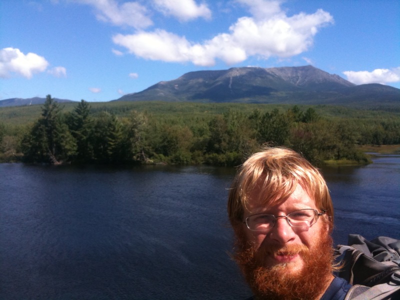
Day 163 - 8/25 - KATAHDIN!!!

Total trail mileage: 2179.1
Starting location: The Birches Lean-to
Ending location: Katahdin, ME!!!!
Weather: 59 degrees in the morning. 63 - 67 degrees during the day.
I am at
http://maps.google.com/maps?q=45.904401,+-68.921478
I MADE IT!!! I have now finished hiking all 2179.1 miles of the
Appalachian Trail. It took me 163 days and I traveled through the end
of Winter, Spring, Summer, and the beginning of Fall. I walked
through 14 states from Springer, GA to Katahdin, ME. I climbed
countless mountains and I have no idea how many feet of elevation
gain. That was a whole lot of steps for man, one tiny bunny hop for
mankind. But, I have made it.
Meeting up with my dad and Lauren wasn't a problem and we got started
by 7:20. Yep, the climb was steep, but it sure was spectacular. A
large part of the climb is above treeline. The views are amazing.
Now I just need to get back down from Katahdin...I'll post more later.
Tuesday, August 24, 2010
Day 162 - 8/24
Total trail mileage: 2173.9
Starting location: Hurd Brook Lean-to
Ending location: The Birches Lean-to
Weather: 64 degrees in the morning. 68 - 79 degrees during the day.
Clear and sunny all day.
I am at
http://maps.google.com/maps?q=45.885738,+-68.993609
I got a late start since I only had to do 13 easy miles today. I
survived the 100-Mile Wilderness and then made my way down to Abol
Bridge. Katahdin got really big now. There was a fantastic view from
the bridge, and today was a really, really nice weather day. Too bad
I didn't summit today. Right past the bridge was the Abol Bridge
Campground and Campstore. I picked up lunch there as well as some
food supplies to get me through today and tomorrow. I hung out there
for a long time. After that I stealth showered in the Campground.
The shower was coin operated, but I think it was only for registered
guests. Well, nobody said anything or questioned what I was doing as
I walked in, took a quick shower, walked out, and headed down the trail.
After that was a pleasant walk through Baxter State Park. The trail
was very flat, devoid of most rocks and roots, and traveled along many
streams, rivers, waterfalls, and ponds. The weather was so nice today
that I didn't really feel like walking though.
I made it to Katahdin Stream Campground and registered with the
Ranger. I am northbound thruhiker #194 for this year. I think I was
#60-something at Harpers Ferry, but that was before my time off
trail. I really thought there were more people ahead of me. Well, I
registered at the Ranger station in the Campground, but the shelter
that they put us in is way away from the Campground. I guess they
think we stink so bad that there is no way they would put us near the
normal guests. So, one final night in my hammock in the woods.
I am not really done with Maine yet, but I am practically there. The
biggest distinguishing attribute of Maine is water. This is a serious
drought year for Maine, and yet there was still water everywhere.
There were plenty of ponds, lakes, streams, rivers, waterfalls, bogs,
puddles, mud pits, etc. There were still mountains with views (and
steep climbs), but there was plenty of hiking along the lower
elevations as well. Maine was one of my favorite states on the trail.
So, tomorrow is Katahdin. 5.2 miles left to go and 4000+ feet of
elevation gain. Much of the climb is above treeline. I can't believe
I am at this point. The plan is (and I hope this works out as I
haven't been able to talk to anyone for a bit) to meet my parents and
my highschool friend Lauren (whom I haven't seen since highschool) in
the Campground in the morning. Then my dad, Lauren, and I will hike
to the top. I might hike the Knife's Edge trail after reaching the
summit depending on the weather. Then, down the mountain and into town
to begin my life after the trail. One possible hiccup is the
weather. The latest report indicated that it will be clear in the
morning, but then clouds and rain will move in during the late
morning. There is a 100% chance of rain in the afternoon. But, this
is a better report than the Thursday report.
Other than seeing people from home, the things I am most looking
forward to in "real world" life are the ability to take showers every
day and the ability to cook real food. I am not looking forward to
the cars, general bussyness, and waste that society brings. I will
miss the quiet and peacefulness found on the trail as well as the
opportunity to see new things, meet new people, and stay active. What
I will miss most though are the people on and around the trail that
have been so generous and friendly. I am hoping to be able to give
back. Not just to the trail community but to strangers at home as
well. As I transition back into the "Real World", I am also hoping to
remain active (maybe not 15-20 mile active, but whatever I can manage)
and to live a simpler life. The trail has taught me that one can live
on very little and still be comfortable. These might be lofty goals,
but I will try my best.
1 more day left on the trail :(
Monday, August 23, 2010
Day 161 - 8/23

Total trail mileage: 2160.5
Starting location: Nahmakanta Lake Campsite
Ending location: Hurd Brook Lean-to
Weather: 62 degrees in the morning. 63 - 73 degrees during the day.
Cloudy all day. A little drizzle midday.
I am at
http://maps.google.com/maps?q=45.818568,+-69.018424
MOOSE REALLY DO EXIST!!! I FINALLY SAW TWO :). The sighting occured
at 7pm on Rainbow Ledges. Wow, they are big creatures. They ran in
different directions when they saw me. I was stunned, so it took me a
few seconds to remember to pull out my camera. I did get a blurry
picture of one of the moose jumping across the trail. The sounds they
made when running through the woods sounded just like what I heard the
other day and before Saddleback, so I am guessing both of those times
were also moose that I just couldn't see.
The rest of the day was also great. The trail has continued to be
nice, especially with the changing leaves. It passed by more ponds,
lakes, streams, and waterfalls today. Rainbow Lake had really, really
clear water. Unfortunately though there were big leaches (4-6 inches)
in it. Katahdin keeps getting bigger and bigger. There was a really
nice view from Rainbow Ledges right after I saw the moose.
There have been a lot of great campsites throughout the Wilderness.
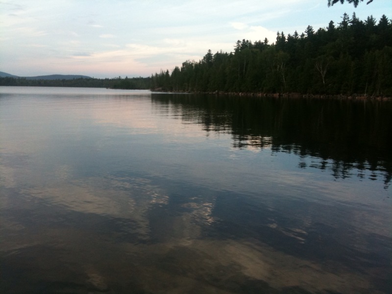
Cloud Pond Lean-to, Antlers Campsite, Nahmakanta Lake Campsite,
Rainbow Springs Lean-to, and Rainbow Lake have been the highlights.
Too bad I couldn't stay at all of them.
I don't want the trip to end. I did manage to get another night in
the woods by not going all the way to Abol Bridge, but tomorrow I have
to head to the Campground. I only have a couple more miles left
before emerging from the Wilderness. Then I will head to the Abol
Bridge Campstore to pick up a few more supplies (and icecream and
beer!).
18.6 miles left to go. 1 night remains.
Sunday, August 22, 2010
Day 160 - 8/22

Total trail mileage: 2138.3
Starting location: Crawford Pond
Ending location: Nahmakanta Lake Campsite
Weather: 60 degrees in the morning. 63 - 73 degrees during the day.
Cloudy all day.
I am at
http://maps.google.com/maps?q=45.737533,+-69.107598
With each day, the forest is becoming more alive with colors. Today
half the ferns turned yellow. A lot of the leaves are starting to fall.
I am really enjoying the 100-Mile Wilderness. Yes, there are cars and
access points, but the number of roads are far less frequent. The
trail has been very pleasant and there have been tons of ponds and
lakes and streams along the way. I was making really good time today
as the trail was pretty flat.
I have been hiking with Red Beard, Minus, and Kagel for the last week
or so. Tonight we camped next to a lake and built a fire. We found
fresh water mussels and cooked them over the fire. They were smoked
over white birch and freshly seasoned with olive oil and ramen
spices. They weren't the best, but they were free calories.
I am running low on food. The trail magic yesterday and the trail
magic today (a woman was at one of the logging roads with oranges and
sodas) has helped a lot, but I am just burning too many calories now.
Good thing I am almost out of the Wilderness. I think I will be
leaving with an empty food bag, but not starving (well, more than
normal).
This might be my last night really in the woods. I have two more
nights, but they both might be in campgrounds. It depends on where I
end up tomorrow night. I can't say I am completely excited about
being at the end.
Unfortunately, I heard that the weather forecast now looks iffy for my
Katahdin summit on Wednesday. Hopefully the forecast turns more
favorably.
40.8 miles left to go!
Saturday, August 21, 2010
Day 159 - 8/21

Total trail mileage: 2117.1
Starting location: Carl A. Newhall Lean-to
Ending location: Crawford Pond
Weather: 58 degrees in the morning. 60 - 74 degrees during the day.
Partly cloudy all day.
I am at
http://maps.google.com/maps?q=45.615831,+-69.126676
I saw Katahdin! There was a really good view of the mountain from
White Cap. White Cap had really nice views in general as well. The
trail down obviously had a lot of work done to it. There were really
nice stone steps most of the way.
The rest of the day was easy. I made good time. Everyone said that
after White Cap the trail is pretty much level until I reach
Katahdin. So far that is true.
The leaves are really starting to change now. Some of the leaves are
red, yellow, and orange. It is starting to feel like Fall too. I am
glad I am getting a few days of Fall before finishing up.
I am camping near a pond. There are 4 others here, 3 of which
thruhiked last year. One of the girls broke her arm at this point
last year and continued to hike to Abol Bridge until it could be taken
care of. They gave me a bit of left over food and Snickers.
62.0 miles left to go!
Friday, August 20, 2010
Day 158 - 8/20

Total trail mileage: 2100.5
Starting location: Cloud Pond Lean-to
Ending location: Carl A. Newhall Lean-to
Weather: A little rain last night. 56 degrees in the morning. 59 -
69 degrees during the day. Clear and Sunny all day. Very windy last
night and during the day.
Today had a lot of great views. Everything in sight was forest,
lakes, or mountains. No man made structures. And, the weather was
gorgeous. It was nice to have a cool day again.
There were a lot of day hikers though once I got near Gulf Hagas. So
much for it being "Wilderness". I was originally planning on hiking
the full Gulf Hagas side trail, but a lot of people said that the
waterfalls aren't nearly as spectacular as normal given the low water
levels this year. I decided to just go a little off the AT to see the
first falls. There were huge pools of water in the gorge, and I
finally found a way to climb down to water level. I went swimming
briefly in one of the pools, but the water was really cold. The pool
was over my head.
Before swimming I got stung by a bee on my leg. It still hurts, but
the cold water helped to dull the pain. Hopefully it doesn't swell up.
I am eating too much food now. My hunger level went even further up.
I should have enough food, but my bag will probably be empty by the
time I reach Abol Bridge. At least my pack weight is getting to be
more reasonable again.
78.6 miles left to go! There are only 2 more climbs left greater than
1000 feet of elevation gain. One is tomorrow. The other is
Katahdin. I am guessing that tomorrow will be the last time I get
phone reception before I finish, so this will likely be the last post
for a couple days.
Thursday, August 19, 2010
Day 157 - 8/19

Total trail mileage: 2083.7
Starting location: North Pond
Ending location: Cloud Pond Lean-to
Weather: 61 degrees in the morning. 68 - 82 degrees during the day.
Clear and Sunny all day.
I am at
http://maps.google.com/maps?q=45.418836,+-69.354214
Today was a nice day of hiking. The weather was great, and the trail
passed by many streams and waterfalls. A few of the waterfalls were
flowing through rocky rivines. There were a few fords, but they were
mostly rock hops this year. I was almost across one when there was a
gap that was just a little too far to cross. I could have gone back
to find a better way, but it was easier to get my one foot a little
wet. It dried out quickly.
I stopped at one of the shelters for lunch. A chipmunk joined me and
would not go away. I was pushing it around with my trekking pole and
tapping it on its side. It didn't care.
I heard something big move through the forest off the trail. By the
sound it had to be either a deer, moose, or bear. I haven't seen any
signs of deer in a long time, so I am guessing it wasn't that.
Unfortunately I could not get a view because the forest was too thick.
The Barren Ledges and Barren Mountain had awesome views. So, of course
I stopped for a while at both points. On top of Barren Mountain there
was the sketchiest tower along the AT. The top platform was gone, and
the stairs were replaced with an iron ladder. I went up it (even
better views), but I couldn't also bring my camera. So, no pictures
from the top.
Cloud Pond is a really nice spot. The water was warm, but I didn't go
swimming. If I got here earlier in the day I would have.
I suppose I can now start to list the remaining mileage. 95.4 miles
left to go. Under 100! And today was the last Thursday on the trail
(assuming I get good weather to summit next Wednesday).
Wednesday, August 18, 2010
Day 156 - 8/18

Total trail mileage: 2068.4
Starting location: Blue blaze to Monson
Ending location: North Pond
Weather: 72 - 76 degrees during the day. Partly cloudy all day.
I am at
http://maps.google.com/maps?q=45.353295,+-69.486205
I woke up and had a monster breakfast at the hostel (3 pancakes, 5
eggs, 7 pieces of bacon, 7 sausage links, and a pile of home fries).
It was great and was my last real meal before Katahdin. After that, I
resewed my pack again but this time with much thicker thread that my
mom sent. Hopefully it holds this time. If not, I have more thread
and needles with me.
I got back on trail by 10, which was later than I was hoping but about
what I was expecting. I started out with a good pace. Although, as
soon as the coffee wore off the lack of enough sleep started to affect
me. I quickly realized that the only way I was going to make it to
Cloud Pond was if I hiked the last bit in the dark. I didn't feel
like doing that, so I started to look for a good campsite as I walked
along.
Then I found one. North Pond is fantastic with small islands and
peninsulas. There was a clearing near the edge of the water at a bend
in the pond. It isn't the clearest view of the main body of the pond,
but I can see down one branch of it. So, I set up my hammock.
I am now in the 100-Mile Wilderness. The sign when I entered said to
turn around if I wasn't carrying at least 10 days worth of food.
Oops. I guess I should go back.
I am on the hunt for moose. I didn't see any tonight, but I am going
to shift my hiking schedule to improve my odds. I will try to get up
early and stay near as many ponds as possible through the Wilderness.
Tuesday, August 17, 2010
Day 155 - 8/17

Total trail mileage: 2061.3
Starting location: After Moxie Bald Mountain
Ending location: Blue blaze to Monson
Weather: Thunderstorm last night. 65 degrees in the morning. 70 -
82 degrees during the day. Clear and sunny all day.
I am at
http://maps.google.com/maps?q=45.285491,+-69.499955
Ugh, I missed a moose sighting. If I continued the last mile in the
dark last night I would have made it to the shelter. Those that were
there saw a moose at 5:30 in the morning.
Today had the first required ford for me that wasn't just a rock hop.
It was only up to my ankle, but most of the fords didn't involve me
getting wet at all. This has been a drought year for Maine, so all
the streams and rivers are very low.
I was going to go to the next road crossing before going into Monson
(another 3 miles), but I would have missed the post office time. So,
I decided to do the 3 miles tomorrow. On the last stretch I ran into
the guy that works at the hostel that I met in the Whites and in
Stratton. He gave me a ride into town.
I saw so many hikers in town that I expected to be much further
ahead. They are all faster hikers, and I had taken the zero and
nero. I have no idea how I caught up.
I had dinner at the pub which turned into hanging out which turned
into drinks. My food ended up being free since they took a while to
bring it out (they were distracted with the Health Inspector coming
through). So, I just had to pay for dessert and drinks. I finally
left as they were closing down. And, I still need to do laundry.
I want to stay at Cloud Pond, which is a bit over 20 miles from here.
So, either tomorrow will be a long day or I will have two short days.
I have enough time to do either, so it all depends on when I get out
in the morning.
Monday, August 16, 2010
Day 154 - 8/16

Total trail mileage: 2045.7 (approx)
Starting location: Pierce Pond Lean-to
Ending location: After Moxie Bald Mountain
Weather: Rain last night. 62 degrees in the morning. 65 - 69
degrees during the day. Cloudy all day. Rain in the morning. On and
off drizzle the rest of the day. Foggy at times.
I am at
http://maps.google.com/maps?q=45.271057,+-69.762014
I got up early, packed up, and headed over to the pancakes. They were
good. Breakfast consisted of 4 rasberry pancakes, 4 blueberry
pancakes, 4 apple pancakes, eggs, sausage, coffee, and juice.
After breakfast I headed down to the Kennebec ferry where Dave the
Ferryman gave me a ride across in the canoe. The Kennebec River can
be a dangerous ford, because there is a dam upstream that releases
water at unscheduled times. The water level can rise 2 - 4 feet
during the time it takes someone to cross. So, the canoe ferry has
become the official AT route. The canoe even has a white blaze in the
bottom of it.
A few leaves are already starting to change. Either they are changing
early this year or Fall in Maine starts much earlier than further
South. I had been saying that my one regret about how I did this trip
was that I wouldn't be able to hike in fall. Perhaps I'll get a few
days of Fall afterall.
I have been seeing and hearing loons for a couple days now. Last
night they were especially loud though. Of course it probably helped
that I was right next to the pond.
The trail today was great. It was really easy terrain followed by a
rocky climb up Pleasant Pond Mountain followed by really easy
terrain. Coming down Pleasant Pond Mountain was slow, but other than
that I was making really good time. I decided to stop at the middle
shelter to make dinner before continueing on and ran into Warcry. I
ended up talking to him and a Southbounder for much longer than I
intended before heading out. Which meant that I was hiking up and
over Moxie Bald Mountain in the fog, mist, and approaching darkness.
Going up the mountain was neat since the rock cairns would emerge from
the fog. However, for the record, coming down wet rock slabs in
failing light is not fun. Miraculously though, I did not fall at
all. Someone said that La Sportiva shoes get better grip after the
rubber has been worn down a little. It seems like that might be
true. I didn't slip too much today even though there were plenty of
wet rocks. I was going very slowly so I didn't lose the trail and
didn't fall. When I got back in the trees I found a place to pitch my
hammock. Hiking the remaining mile or so to the shelter will be much
quicker in the morning when I have light.
Tomorrow I head into Monson. Monson is my last time off trail before
entering the 100-Mile Wilderness and climbing Katahdin. Just over 130
miles to go!
Sunday, August 15, 2010
Day 153 - 8/15

Total trail mileage: 2023.9
Starting location: West Carry Pond Lean-to
Ending location: Pierce Pond Lean-to
Weather: 56 degrees in the morning. 73 - 81 degrees during the day.
Clear and sunny all day.
I am at
http://maps.google.com/maps?q=45.240339,+-70.055485
The trail today was great. It was very gradual and had minimal rocks
and roots. It was close to the easiest terrain that the AT offers.
And, it passed by a number of really nice ponds. And yet, I did a
short day.
I had to stop at Pierce Pond because of the famous pancakes tomorrow
morning and because of the timing of the Kennebec ferry. So, it was a
forced short day. The next two days will be longer though.
When I got to the shelter, I set up my hammock directly next to the
pond. Then, I went swimming for a few minutes. After that, a few of
us walked over to Harrison's Camp to let them know we will be coming
for breakfast and to fill up our water bottles with "wicked good
water". I saw the falls and the tons of hummingbirds at the feeders
right outside the cabin.
I returned to camp, made dinner, chatted with the thruhikers and past
thruhikers about places along the trail, and then am going to bed
early. Mmm, I can't wait for pancakes.
Saturday, August 14, 2010
Day 152 - 8/14
Total trail mileage: 2013.9
Starting location: West Carry Pond Lean-to
Ending location: West Carry Pond Lean-to
Weather: 71 - 77 degrees during the day. Clear and sunny all day.
I am at
http://maps.google.com/maps?q=45.158124,+-70.099633
I sat around all day and pretty much did nothing. It was great. I
got up in the morning when the rest of Team 22 (those that had
previously been planning on summitting on the 22nd) showed up. They
were continueing on though and were just stopping for a food break.
After that I ate breakfast, read some, took a nap, read some more,
cooked some food, hung out at the pond, and read some more. By late
afternoon someone else showed up and then a few people from across the
pond arrived by boat with brownies, beer, and other goodies. Then a
Dragon Fly and a few section hikers came in. It was a more relaxing
zero than in town, because I didn't have to take care of any chores.
Short day tomorrow to Pierce Pond where I can get pancakes the
following morning.
Friday, August 13, 2010
Day 151 - 8/13

Total trail mileage: 2013.9
Starting location: Avery Memorial Campsite
Ending location: West Carry Pond Lean-to
Weather: 53 degrees in the morning. 74 - 78 degrees during the day.
Clear and sunny all day.
I am at
http://maps.google.com/maps?q=45.158124,+-70.099633
We got a late start this morning. Rather than getting up at 2am like
planned we got up at 2:30am. I had set a backup alarm for 2:30, and
it was fortunate that I did.
I packed up everything in the dark and started hiking up to the
summit. Fortunately a moose didn't come down the trail in the middle
of the night and accidentally step on me. I was out of water so I was
hoping to pick some up at a spring on the way to the summit. Well,
the spring was dry, but there was a muddy puddle nearby. Rather than
hunt around in the dark for better water, I decided to filter the
muddy water. I am glad I have a filter rather than purification
tablets for times like these.
After I got water, I continued to the top, wedged myself in between a
rock crack, and made dinner/midnight snack/breakfast and tea. Apple
Juice, Scout, Smokestack, Zen, and Devo arrived shortly after.
Avery Peak was probably an ideal location to watch the meteor shower
from as well as look at the stars. The night was so clear, and we
were on top of a ridge above treeline. It was fantastic. It was such
a rewarding experience, and I am definitely glad I got up early for
it. The sky was the clearest I have seen stars since I was in New
Zealand.
But, it was cold. I had on most of my clothes including my down
vest. Zen pulled out her sleeping bag. The temperature wasn't really
that cold (low 50s), but there was no protection from the wind and we
weren't moving.
When the sun started to come up, we moved 100 yards along the ridge to
be near an old building up there. That point was better to watch the
sunrise from, and the building shielded us a little from the wind.
One of the windows of the building was broken out, so we climbed
inside for a bit. There was a bunch of broken glass and entering
probably wasn't the best idea, but fortunately nobody got hurt. The
sunrise was the best sunrise I have seen all trip. Again, it was
definitely worth getting up early for it.
After the sun was up it was a normal day. I passed the 2000-mile
mark! I can't believe I have walked over 2000 miles in the last 6
months. I took a lot of breaks during the day since I was in no rush
and still got to West Carry Pond fairly early. They rerouted some of
the trail since I was last in this area (12 years ago?). I do
remember the dirt road, the pond, and the lean-to though. I decided
to stay at the pond and will likely zero here for the sake of zeroing
somewhere on trail.
I went swimming in the pond for a bit. It was crazy to think that I
had most of my clothes on in the morning to try to stay warm and I was
swimming by the afternoon to cool off. The water wasn't too cold.
There were a number of small, furry creature encounters today. I
stopped for a quick break on the trail, and a squirrel started to
angrily chirp at me. I looked up, and it was sitting on the branch
and would try to false-charge me. I don't know what it thought it
would do. Then at lunch there was a chipmunk that would come within a
foot of my leg to try to get a crumb. It was all over the place and
wasn't afraid of humans at all. Then, when I was sitting at the lake
I saw a ferret-like creature run along the rocks. I don't know what
it was, but it had a body like a ferret, just smaller.
My pack is continueing to fall apart. My repair job on the shoulder
strap wore through the other day so I had repaired it again. Today
the zipper for the top compartment broke, rendering that pouch
useless. Good thing I can fit everything inside the main
compartment. Katahdin is definitely the end of this pack's life.
I forgot to mention yesterday that barring bad weather when I try to
go up Katahdin, my summit date has been set. I should be finishing
August 25, which is less than 2 weeks from today. That gives me
enough time to take it easy through the rest of the trip.
Day 150 - 8/12

Total trail mileage: 1999.3
Starting location: ME 27
Ending location: Avery Memorial Campsite
Weather: 69 - 74 degrees during the day. Mostly clear and sunny all day.
Consuming 7 slices of pizza, a pint of ice cream, and a bottle of soda
immediately before climbing a mountain was not a good idea. The first
few miles were painful. Having a full pack out of resupply didn't
help either. Interestingly, the hike got easier as the mountain got
steeper. By then i had digested some of the food.
On the way up I passed by a pond. A beaver was swimming around and
didn't care that I was there. Unless it was blind, deaf, and had no
sense of smell, it knew I was at the edge of the pond. It got within
5 to 10 feet of me and was still just floating around.
I got up to the west peak of Bigalow Mountain and waited for sunset.
It was above treeline and the sunset was fantastic. Then, I hiked the
remaining 0.3 miles to the campsite.
I was expecting to see Zen, Devo, and Apple Juice there, but I was not
expecting to see Smokestack and Scout. They had both said that they
really needed to push on. Since our plan was to get a couple hours of
sleep and then get up around 2am to hike up Avery Peak for the Meteor
Shower, I didn't want to waste time setting up and taking down my
hammock. Besides, the campsite was pretty full. Smokestack had found
a spot for his hammock and Apple Juice and Scout were Cowboy camping
on the ground there. So, I also rolled out my pad and am going to
sleep literally 2 feet from the trail. If I roll over I will be in
the middle of the trail.
While sitting here a small owl decided to fly all around our camp. It
was flying from branch to branch and was watching us. We became
paparazzi and all had our cameras out. So, when someone saw the owl
flashes would start going off.
Tomorrow will be a very early start. I am going to shoot for either
West Carry Pond or Pierce Pond. I had planned on doing a zero on
trail at some point during this trip. This was the area that I had
been thinking of doing so. And then there are legendary pancakes near
Pierce Pond. So, the next few days might be easy days.
Wednesday, August 11, 2010
Day 149 - 8/11

Total trail mileage: 1991.3
Starting location: Spaulding Mountain Lean-to
Ending location: ME 27
Weather: 59 degrees in the morning. 60 - 73 degrees during the day.
Cloudy and foggy in the morning. Partly cloudy the rest of the day.
I am at
http://maps.google.com/maps?q=45.140581,+-70.443472
The beginning of the day was pretty easy. But, then the climb up
Crocker Mountain was really steep. It was around a 1500 ft ascent in
1 mile. But, it wasn't rock slabs so I didn't slip at all while going
up. After a long gradual descent from there I arrived at the road
where there was a cooler with sodas.
I started to try to hitch into town when a truck coming in the
opposite direction pulled over. It turned out to be the ridge runner,
and he was bringing Scout back to the trail. He offered to bring me
into town. Apple Juice and Smokestack then showed up.
Zen and Devo were already in town. Unfortunately I missed the post
office hours by 10 minutes. After a shower I got dinner, which
included a Wolf Burger. A Wolf Burger had bacon, cheese, and a
sausage patty on it. After that was the typical pint of ice cream.
Tomorrow I will head back to the trail but will only do 8 miles.
There is a campsite right below the exposed Avery peak. There is
supposed to be a meteor shower and that should be the clearest place
to watch it from.
Tuesday, August 10, 2010
Day 148 - 8/10

Total trail mileage: 1977.8
Starting location: Piazza Rock Lean-to
Ending location: Spaulding Mountain Lean-to
Weather: 65 degrees in the morning. 65 - 79 degrees during the day.
Partly cloudy most of the day. Cloudy, thunder, and showers in the
late afternoon.
I am at
http://maps.google.com/maps?q=44.995683,+-70.341478
The hike today was great. Again, I lucked out with weather and had
fantastic views from Saddleback Mountain, The Horn, and Saddleback
Junior. The trail was above treeline for a lot of that hike and the
climbs weren't too bad. This was the terrain that I had 5 months of
training for. There is a lot of elevation gain and loss, but I could
hike it rather than climb it. And then the latter part of the day was
really, really nice. There weren't too many rocks or roots and the
trail was gradual and dry. It was going through a forest that was
fairly open, but it was green because of the ferns and moss.
I passed the 90 percent point today. About 200 miles left to go! I
want to finish, but I don't want the trip to end.
Apple Juice and I were sitting and talking at the previous shelter
when I noticed a creature emerge from the woods. I thought it was a
dog, but then realized it was a rabbit. A very big rabbit. Apple
Juice thinks it was a snowshoe rabbit with its summer coat. The feet
were huge.
In the late afternoon I started hearing thunder, the sky got very
dark, and the wind picked up. I was expecting to get drenched at any
moment, but the rain didn't come. It did shower a little bit but only
after the thunder cleared off and the sky got less dark.
It seems like everyone is falling apart as soon as we hit Maine.
There have been a number of people sick, and they have been forced to
take 3-4 days off. There have been a number of injuries. A few have
been talking about the possibility of quiting. Fortunately my only
problem has been my pack falling apart (my repair job is holding for
now).
Tomorrow I head into Stratton for a night off and to get more
supplies. It is my second to last resupply point. I am a day ahead
of my revised schedule, but now that I am so close to finishing I will
need to make the rest of my schedule more firm.
Monday, August 9, 2010
Day 147 - 8/09

Total trail mileage: 1960.9
Starting location: Bemis Stream
Ending location: Piazza Rock Lean-to
Weather: Rain last night. 67 degrees in the morning. 68 - 73 degrees
during the day. Cloudy in the morning. Partly cloudy in the
afternoon. Thunder in the evening.
I am at
http://maps.google.com/maps?q=44.835386,+-70.721852
Today had a lot of ponds. I passed at least a half dozen today. At
one of the ponds there was a sandy beach. It was cold, but it was too
good to pass up. So, I had to go swimming. And then I sat around for
a while as I dried off.
There was also a lot of mud today. There were a number of bog
bridges. Some were using other bridges for support. Some were
floating in the water and mud at one end, so when you stepped on it
the bridge would go under water. In one spot, I stepped on a log,
another bridge started sinking, and a third started twisting. It was
like the staircases in Harry Potter. But, all in all it wasn't too bad
and I didn't get too wet or muddy.
I got to the Lean-to along with Apple Juice, Smokestack, Scout, and
Iceman. I decided to stay in the shelter for the first time in a very
long time since it looked like it was about to storm and I didn't feel
like setting up my hammock.
Tomorrow I head up Saddleback Mountain. Hopefully there are good
views in the morning.
Sunday, August 8, 2010
Day 146 - 8/08

Total trail mileage: 1945.2
Starting location: Surplus Pond
Ending location: Bemis Stream
Weather: 51 degrees in the morning. 64 - 71 degrees during the day.
Cloudy all day. Drizzle in the early evening.
I did a 20 mile day! It has been a long time since I have hiked more
than 20 miles in a day (without checking I think the last time was in
Vermont). And, as far as 20+ milers go, today probably had the
toughest terrain. There were a number of long and steep climbs and
descents (Wyman Mountain, Moody Mountain, Old Blue Mountain) and a
bunch of smaller climbs. But, for the most part the trail was nice
today. This was probably the last time I will do a 20-mile day for
the rest of the trip.
I crossed two streams today that are usually fords. I rock-hopped
them. People said the water has been chest high before at both
streams. I am hoping that means the rest of the fords coming up will
also be easy to cross.
In the early evening it started to drizzle. Once it started raining a
little harder I decided to stop and put on rain gear. After I got my
rain coat out of my pack and my pack cover half on, the rain stopped.
If I always had my rain gear on it would never rain.
At the first shelter today the chipmunks were all over the place. One
was eating something off the ground and was maybe 3 feet from me. The
whole time it was watching me and if I made any movement it would dart
away. One chipmunk found a candy wrapper that someone had left. It
was crawling inside and throwing it around trying to find food.
I might try to get part way up Saddleback tomorrow, but I'll see what
the trail is like.
Saturday, August 7, 2010
Day 145 - 8/07

Total trail mileage: 1924.5
Starting location: East B Hill Rd
Ending location: Surplus Pond
Weather: 64 - 81 degrees during the day. Mostly clear and sunny all
day.
I am at
http://maps.google.com/maps?q=44.673410,+-70.863291
After waking up and taking care of resupply, I headed down the street
to get breakfast. The main street was a zoo because of the festival.
It was especially crazy because Andover is such a tiny town. I was
able to get a table in the restaurant though. After a full breakfast
I picked up a pint of ice cream and returned to the hostel.
Sweettooth had just finished a 4.5 mile race (he came in first for his
age group), and Sweettooth and Bugsy were headed to the parade so I
joined them. We saw firetrucks from probably every nearby town. They
were giving out candy to the kids, but they didn't have any pity on
thruhikers. We then had a BBQ chicken meal at the fire station while
Smokestack and Apple Juice entered a pie eating contest. The contest
wasn't what we had imagined though. The person that won had to eat
the pie the fastest without using their hands. Thruhikers are
endurance eaters not sprinters, so the two only received honorable
mentions. After that we had fried dough, looked at the submissions to
the photography competition, and saw all the historic cars that had
been assembled.
After that I returned back to the hostel to see what time everyone was
getting shuttled back to the trailhead. It turned out that the time
was set for 3pm, and people had just started watching Ocean's 11.
While watching the movie, I was contemplating taking another zero, but
I should keep moving or I will never finished. When we were loading
up the van though, everyone else except Smokestack and me decided to
bail and take a zero.
I got back on trail by 3:30, but I wasn't committed to hiking through
the rest of the daylight. I just wanted to get back on trail, because
breaking free from town is always the hardest part. Now that I am out
here I can more easily get going tomorrow. So, when I saw a really
nice campsite next to a pond, I decided to stop despite going less
than 2 miles.
I read the rest of the afternoon. I was hoping to see a moose by the
pond as there are lots of nearby droppings. No moose yet, but I did
see a beaver swimming around. The temperature dropped quite a bit and
I had to actually put on my fleece.
I am hoping to do a long day tomorrow and get back on track. There is
supposedly a pond up ahead with a nice sandy beach for swimming. That
might be out of my reach tomorrow, but that all depends on how early I
can get started and what the terrain is like.
Friday, August 6, 2010
Day 144 - 8/06

Total trail mileage: 1922.6
Starting location: After Old Speck Mt.
Ending location: East B Hill Rd
Weather: 58 degrees in the morning. 63 - 68 degrees during the day.
Partly cloudy in the morning. Cloudy in the afternoon. Rain in the
afternoon.
I am at
http://maps.google.com/maps?q=44.668373,+-70.893199
Today was hikeable! Actually I made really good time. Sure there was
a mountain to climb up and over, but most of it was either fairly
gradual or had stone or root steps. There were only a few sections of
the slick rock slabs.
Baldpate Mountain was awesome. There were great views and it was all
exposed. Climbing up to the peak was climbing an enormous rock, but
the rock had natural steps worn into it. Fortunately I was well off
the top by the time the rain started.
I was able to arrange for a shuttle into the hostel before I descended
to the road. It was good that I was able to as there was no reception
at the road, there was almost no traffic to try to hitch from, and the
town is 9 miles from the trail.
It turns out that tomorrow is Andover's annual festival. It looks
like a very tiny town, but there a bunch of people here for the
event. There are rumors of a pie eating contest, so I may have to
enter prior to returning to the trail.
Apple Juice had a sewing kit so I tried my best to repair my pack. I
am sure it won't last long though. I am just hoping it lasts long
enough to get to Katahdin.
Subscribe to:
Posts (Atom)